 Learn with me publication
- Books Name
- Learn with me Social Science Book
- Publication
- Learn with me publication
- Course
- CBSE Class 9
- Subject
- Social Science
The Indus River System
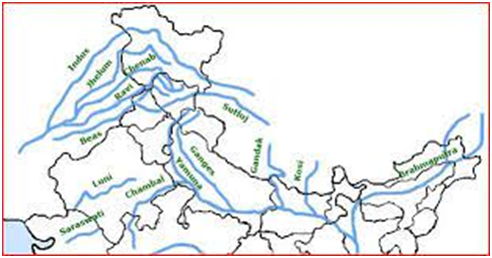
• Rising near Lake Mansarovar in Tibet, the Indus enters India in the Ladakh district of Jammu and Kashmir.
• Zaskar, the Nubra, the Shyok are the tributaries in Kashmir.
• Rivers Satluj, Beas, Ravi, Chenab and Jhelum join Indus near Mithankot, Pakistan and flow southwards to fall into the Arabian Sea, east of Karachi.
• With a total length of 2900 km, the Indus is one of the longest rivers of the world.
• India and Pakistan have distributed Indus river water according to Indus Water Treaty in 1960.
The Ganga River System
• The headwaters of the Ganga are called ‘Bhagirathi’ is fed by the Gangotri Glacier and joined by the Alaknanda at Devprayag in Uttarakhand.
• Ganga meets the tributaries from the Himalayas such as Ghaghara, Gandak and Kosi.
• A major river Yamuna, arising from Yamunotri Glacier in the Himalayas, joins Ganga at Allahabad.
• Other tributaries — Chambal, Betwa and Son — come from Peninsular uplands to join Ganga.
• Farukka in West Bengal is the northernmost point of the Ganga Delta.
• Ganga is joined by Brahmaputra and forms river Meghna which flows through Bangladesh to reach the Bay of Bengal.
• The delta formed when the Ganga and the Brahmaputra flow into the Bay of Bengal is known as the Sunderban Delta.
• The length of the Ganga is over 2500 km and it develops large meanders in the downstream plain areas.
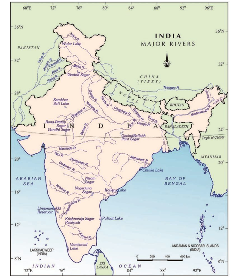
The Brahmaputra River System
• Originating in Tibet, very close to the sources of Indus and Satluj, Most of its course lies outside the India.
• On reaching Namcha Barwa it takes a ‘U’ turn and enters in Arunachal Pradesh to flow to Assam joined by many tributaries.
• The tributaries that join Brahmaputra are Dibang, Lohit, and Kenula.
• The Brahmaputra has a braided channel in its entire length in Assam to form many riverine islands. World’s largest riverine island is found in Brahmaputra.
• Unlike other north Indian rivers, the Brahmaputra is marked by huge deposits of silt on its bed, causing the riverbed to rise.
The Peninsular Rivers
• Western Ghats form the main water divide in peninsular India.
• The major rivers of the peninsula — Mahanadi, Godavari, Krishna and Kaveri — flow eastwards to drain into the Bay of Bengal.
• The Tapi and Narmada are the only rivers which flow west to make estuaries and drain into the Arabian Sea.
• The drainage basins of the peninsular rivers are comparatively small in size.
Lakes
• Most lakes are permanent while other contain water only during the rainy season.
• Some lakes are result of the glacial action and ice sheets and some may have been formed by wind, river action and human activities.
• A river meandering across a floodplain forms cut-offs that later develop into oxbow lakes.
• Glacial lakes are formed when glaciers dig out a basin which is later filled with snowmelt.
• Some lakes like Wular Lake in Jammu and Kashmir result from tectonic activity.