 Param Publication
Chapter 1: Environment
- Books Name
- CBSE Class 7 Social Science Book
- Publication
- Param Publication
- Course
- CBSE Class 7
- Subject
- Social Science
* INTRODUCTION :
![]()
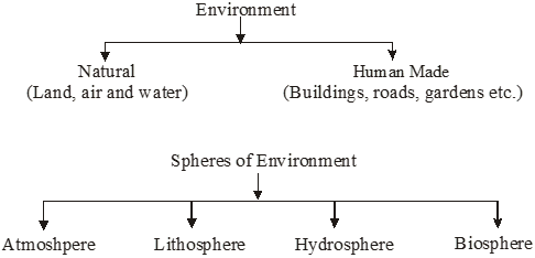
* WHAT IS ENVIRONMENT?
Literally, environment means surroundings or conditions under which a person or a thing exists and develops his/its characteristics. For example, the environment of a plant refers to all those conditions which help the growth of that particular plant. Like soil, rainfall, temperature etc.
Environment is combination of natural environment and human made phenomena. 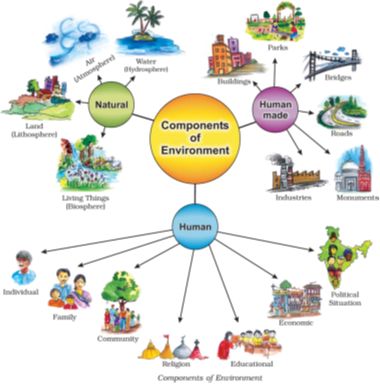
The natural environment refers to both biotic and abiotic conditions existing on the earth.
Biotic: The world of living organisms. E.g. plants and animals.
Abiotic: The world of non-living element. E.g. land.
Human Environment reveals the activities creations and interactions among human beings.
* NATURAL ENVIRONMENT
Land, water, air, plants and animals comprise the natural environment.
* MAJOR SPHERES OF ENVIRONMENT
The major spheres of environment are the following :
(i) Atmosphere (ii) Lithosphere (iii) Hydrosphere (iv) Biosphere.
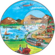
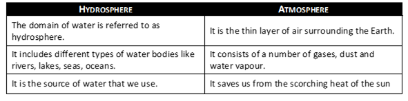
* ATMOSPHERE
The air-envelope that surrounds the earth is called the atmosphere. It is a mixture of many gases such as nitrogen, oxygen, argon, carbon-dioxide etc. It also contains water vapour, dust and smoke particles. It is to be remembered that the atmosphere extends a little beyond 1,600 kilometres from the earth.
Importance of the Atmosphere
The atmosphere is very important to us. It has many advantages of its own :
(1) The atmosphere acts like a blanket or a glass house for the earth. It receives the radiation of the sun but does not allow the insulation to escape. As such it keeps the earth warm.
(2) Water-vapours and carbon-dioxide present in the lower layers of the atmosphere absorb the heat radiated by the earth’s surface and keep the atmosphere warm even during night.
(3) The changes in the atmosphere produce changes in the weather and climate.
* LITHOSPHERE
Another important sphere of the environment is the lithosphere which envelopes its interior portion. The average thickness of the lithosphere comes to be about 100 kilometres.
It has been found that the thickness of the earth’s crust is greater where the continents exist as compared to the ocean floors.
Importance of The Lithosphere
The outer covering or crust of the earth, which is called lithosphere, is of great importance to us.
Its soil cover is indispensable for the growth of plants. Moreover, lithosphere is a source of various mineral resources including those of coal and oil.
The various landforms of the lithosphere can be put to various uses depending upon the economic factors and human needs.
* HYDROSPHERE
Those parts of the earth which are covered by water form the hydrosphere. The oceans, lakes, rivers and other water bodies on the earth form the hydrosphere. About 71% of the earth’s surface is covered with water; so the earth is sometimes called a watery planet. Moreover, the earth is the only planet which has water.
* BIOSPHERE
Life on earth exists in a narrow belt, a little below and above the surface of the land and in water and air. This narrow belt of living organisms, both plants and animals, is called biosphere. This sphere thus includes parts of atmosphere, lithosphere and hydrosphere.
* WHAT IS ECOSYSTEM?
1. Ecosystem it is a system formed by the interaction of all living organisms with each other and with the physical and chemical factors of the environment in which they live, all linked by transfer of energy and material.
2. All plants, animals and human beings depend on their immediate surroundings. Often they are also interdependent on each other.
3. This relation between the living organisms, as well as the relation between the organisms and their surroundings forms an ecosystem.
4. There could be an ecosystem of large rain forest grassland, desert, mountains, lake, river, ocean and even a small pond.
* HUMAN ENVIRONMENT
1. Human beings interact with the environment and modify it according to their need. They led a simple life and fulfilled their requirements from the nature around them. With time, needs grew and became more varied. Humans learn new ways to issue utilise/see and change environment.
2. They learn to grow crops, domesticate animals and lead a settled life. The wheel was invented, surplus food was produced, barter system emerged, trade started and commerce developed. Industrial revolution enabled large scale production. Transportation became faster.
3. Information revolution made communication easier and speedy across the world.
4. A perfect balance is necessary between the natural and the human environment. Humans must learn to live and use their environment in a harmonious way.
* WHY IS EARTH CONSIDERED A UNIQUE PLANET?
The Earth is considered to be a unique planet in the solar system due to the following factors:
1. The distance of the earth from the sun results in such a climate which is best suited for the development of man and other forms of life on the earth.
2. Its atmosphere is rich in oxygen that makes life possible on this planet. It acts as a large cover to protect its surface from extreme cold and heat.
3. On earth, water occurs in cost abundance quantities which makes life possible on the earth, as water is essential for all forms of life.
* GLOSSARY
Environment : The external conditions in which an organism lives.
Physical environment : All the abiotic component of environment like the lithosphere,the atmosphere and the hydrosphere.
Atmosphere : The thin layer of air which envelopes our earth.
Lithosphere : Layer of the earth comprising rock materials, extending to continents and ocean basins.
Hydrosphere : Part of the earth’s surface covered with water.
Biosphere : A very narrow sphere of the earth which sustains life.
Illustration 1
Write difference between biotic and abiotic environment.
Solution
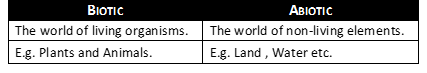
Illustration 2
Difference between Natural and Human made environment.
Solution
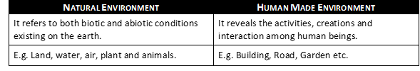
Illustration 3
Distinguish between Hydrosphere and Atmosphere.
Solution
Chapter 10: Life in the Deserts
- Books Name
- CBSE Class 7 Social Science Book
- Publication
- Param Publication
- Course
- CBSE Class 7
- Subject
- Social Science
* Introduction
Desert is an arid region characterised by extremely high and low temperature and as scarce vegetation. Depending on temperatures there can be Hot and Cold Desert.
* The Hot Desert Sahara
* LOCATION
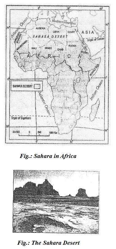
(i) It is the world’s largest desert with an area of around 8.54 million sq. km.
(ii) The Sahara desert touches eleven countries like Algeria, Chad, Egypt, Libya, Mali, Mauritania, Morocco, Niger, Sudan Tunisia and Western Sahara of North Africa.
(iii) Besides the vast stretches of sands, Sahara desert is covered with gravel plains and elevated plateaus with bare rocky surface. These rocky surfaces may be more than 2500m high at some places.
* CLIMATE
(i) The climate of the Sahara desert in scorching hot and parch dry.
(ii) Has a short rainy season.
(iii) The sky is cloudless and clear.
(iv) Here, the moisture evaporates faster than it accumulates.
(v) Days are unbelievably hot and the night may be freezing cold with temperatures nearing zero degrees.
* FLORA
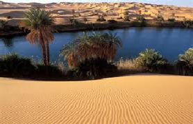
(i) Vegetation in the Sahara desert includes cactus, date palms and acacia.
(ii) In some places there are oasis-green islands with date palms surrounding them.
* FAUNA
Camels, hyenas, Jackals, foxes, Scorpions and many varieties of Snakes and lizards are found in Sahara.
* PEOPLE IN SAHARA
(i) The Sahara desert despite its harsh climate has been inhabited by various groups of people.
(ii) The Bedouins and Tuaregs:-
(a) These groups are nomadic tribes rearing livestock such as goats, sheep, camels and horses.
(b) These animals provide them with milk, hides from which they make leather for belts, slippers, water bottles; hair is used for mats, carpets, clothes and blankets.
(c) They wear heavy robes as protection against dust storms and hot winds.
(iii) The oasis in the Sahara and the Nile Valley in Egypt supports settled population. Since water is available, the people grow date palms.
(iv) Crops such as rice, wheat, barley and beans are also grown.
(v) Egyptian cotton, famous worldwide is grown in Egypt.
(vi) The discovery of oil - a product in great demand throughout the world, in Algeria, Libya and Egypt is constantly transforming the Sahara desert. Other minerals of importance that are found in the area include iron, phosphorus, manganese and uranium.
(vii) The cultural landscape of the Sahara is undergoing change:-
(a) Gleaming glass cased office buildings tower over mosques and superhighways crisscross the ancient camel paths.
(b) Trucks are replacing camels in the salt trade.
(c) Tuaregs are seen acting as guides to foreign tourists.
* The Cold Desert - Ladakh
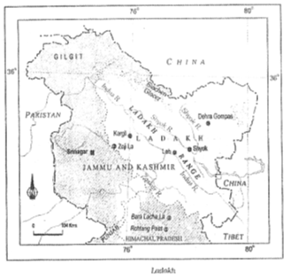
* LOCATION
(i) Ladakh is made up of two words- La meaning mountain pass and Dak meaning country.
(ii) Ladakh is also known as Khapa-chan which means Snowland.
(iii) Ladakh is a cold desert lying in the Great Himalays, on the eastern side of Jammu and Kashmir. The Karakoram Range in the north and the Zanskar mountains in the south enclose it.
(iv) Drass is one of the coldest inhabited places on earth located in Ladakh.
(v) Several rivers flow through Ladakh, Indus being the most important among them. The rivers form deep valleys and gorges.
(vi) Several glaciers are found in Ladakh, for example the Gangri glacier.
(vii) The altitude in Ladakh varies from about 3000 m in Kargil to more than 8,000 m in the Karakoram.
* CLIMATE
(i) Due to its high altitude, the climate is extremely cold and dry. The air at this altitude is so thin that the heat of the sun can be felt intensely.
(ii) The day temperatures in summer are just above zero degree and the night temperatures well below--30°C.
(iii) It is freezing cold in the winters when the temperatures may remain below -40°C for most of the time.
(iv) As it lies in the rain shadow of the Himalays, there is little rainfall, as low as 10 cm every year.
(v) The area experiences freezing winds and burning hot sunlight. For instance, you will be surprised to know that if sit in the sun will your feet in the shade, you may suffer from both sunstroke and frost bite at the same time.
* FLORA
(i) Due to high aridity, the vegetation is sparse.
(ii) There are scanty patches of grasses and shrubs for animals to graze.
(iii) Groves of willows and poplars are seen in the valleys.
(iv) During the summers, fruit trees such as apples, apricots and walnuts bloom.
(v) The finest cricket bats are made from the wood of the Willow trees.
* FAUNA
(i) Several species of birds are sighted in Ladakh like Robins, Redstarts, Tibetan snowcock, Raven and hoopoe are common.
(ii) Some of these are migratory birds
(iii) The animals of Ladakh are wild goats, wild sheep, yak and special kinds of dogs.
(iv) The animals are reared to provide for the milk, meat and hides.
(v) Yak’s milk is used to make cheese and butter.
(vi) The hair of the sheep and goat is used to make woolens.
(vii) The Chiru or the Tibetan antelope is an endangered species. It is hunted for its wool known as shahtoosh, which is light in weight and extremely warm.
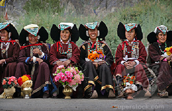
* PEOPLE IN LADAKH
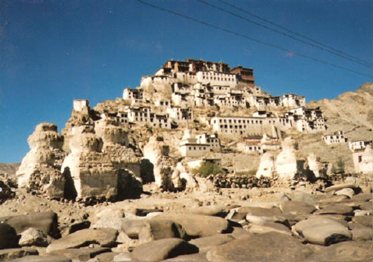
(i) The people here and either Muslims or Buddhists. In fact several Buddhist monasteries dot the Ladakhi landscape with their traditional ‘gompas’.
(ii) Some famous monasteries are Hemis, Thiksey, Shey and Lamayuru
(iii) In the summer season the people are busy cultivating barley, potatoes, peas, beans and turnip.
(iv) The climate in winter months is so harsh that people keep themselves engages in festivities and ceremonies.
(v) The women are very hard working. They work not only in the house and fields, but also manage small business and shops.
(vi) Leh the capital of Ladakh is well connected both by road and air. The National Highway 1A connects Leh to Kashmir Valley through the Zoji la pass.
(vii) Tourism is a major activity with several tourists streaming in from within India and abroad. Visits to the gompas, treks to see the meadows and glaciers, witnessing ceremonies and festivities are important activities.
(viii) Manali-Leh highway crosses four passes, Rohtang la, Baralacha la, Lungalacha la and Tanglang la. The highway opens only between July and September when snow is cleared from the road.
(ix) Life of people is undergoing change due to modernisation. But the people of Ladakh have over (the centuries learned to live in balance and harmony with nature. Due to scarcity of resources like water and fuel, they are used with reverence and care, thus nothing is discarded or wasted.
Chapter 9: Life in the Temperate Grasslands
- Books Name
- CBSE Class 7 Social Science Book
- Publication
- Param Publication
- Course
- CBSE Class 7
- Subject
- Social Science
* INTRODUCTION
Grassland can be defined as a region where grasses from the dominant type of plant life. Grasslands make up almost a quarter of the total land surface. As climate pays an important role in the formation of grasslands, it is generally used as a basis to divide the world’s grasslands into two broad categories: those that occur in the temperate region and those that occur in the tropical regions.
* The Prairies
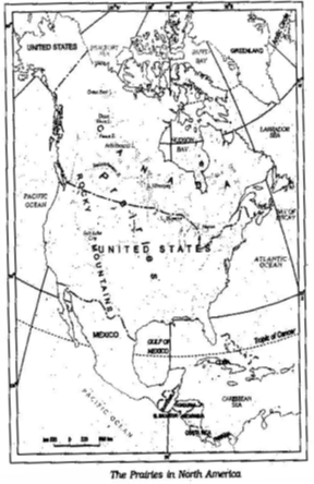
(i) Word Prairie originated from Latin word priata which means meadow.
(ii) The temperate grasslands of North America are known as the Prairies.
(iii) It is a region of flat, gently sloping or hilly land. For the most part, prairies are treeless but, near the low lying plains, flanking river valleys, woodlands can be found.
(iv) Tall grass, upto two metres high, dominates, the landscape.
(v) It is actually a “sea of grass’.
* Location
(i) The prairies are bound by the Rocky Mountains in the West and the Great Lakes in the East.
(ii) Prairies cover parts of United States of America and parts of Canada.
(iii) In the USA, the area is drained by the tributaries of Mississippi and the Canadian prairies are drained by the tributaries of Saskatchewan Rivers.
* Climate
(i) The climate is of continental type.
(ii) The summers are warm with temperatures of around 20°C, while in winter – 20°C has been recorded in Winnipeg, Canada.
(iii) In winters a thick blanket of snow covers this region.
(iv) The annual rainfall is moderate and is ideal for the growth of grass.
(v) Due to the absence of the north-south barrier, a local wind “Chinook” blows here. Chinook is hot wind that blows in winter and therefore raises the temperature in a short time. This increase in temperature results in the melting of snow, making pasture land available for grazing of animals.
* Flora
(i) Prairies are practically tree-less.
(ii) Trees such as willows, alders and poplars grow, where water is available.
(iii) Places that receive rainfall of over 50 cm, are suitable for farming as the soil is fertile.
(iv) The major crop of this area is maize, other crops including potatoes, soyabean, cotton and alfa-alfa are also grown.
(v) Areas where rainfall is very little or unreliable, grasses are short and sparse.
* Fauna
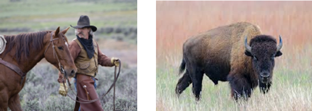
(i) These areas are suitable for cattle rearing.
(ii) Large cattle farms called ranches are looked after by sturdy men called cowboys.
(iii) Bison or the American buffalo is the most important animal of this region which nearly got extinct due to its indiscriminate hunting and is now a protected species.
(iv) The other animals found in this region are rabbits, coyotes, gophers and Prairie dog.
* People
(i) The people of the prairies are very hardworking. They have successfully harnessed technology to utilise their rich natural resources.
(ii) Scientific methods of cultivation and use of tractors, harvesters and combines has made North America a surplus food producer. The Prairies are also known as the “Granaries of the world”, due to the huge surplus of wheat production.
(iii) Dairy farming is another major industry. The dairy belt extends from the Great Lakes to the Atlantic Coast in the east. Dairy farming and extensive agriculture both promote setting up of food processing industries.
(iv) Large mineral deposits particularly coal and iron and a good network of roads, railways and canals in this region have made it the most industrialised region in the world.
(v) Combine: A machine which can sow, plough and work as thresher all by itself.
* The Velds
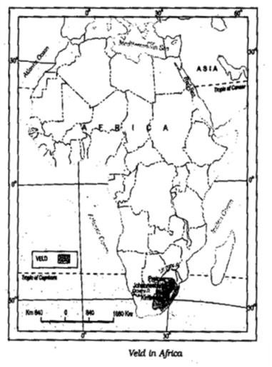
(i) The temperate grasslands of South Africa are called the velds.
(ii) Velds are rolling plateaus with varying heights ranging from 600 m to 1100 m.
(iii) Veld name was given by Dutch settlers.
* Location
(i) It is bound by the Drakensburg Mountains on the east.
(ii) To its west lies the Kalahari desert.
(iii) On the northeastern part, “high velds” are located that attain a height of more than 1600 m, in some places.
(iv) The tributaries of rivers Orange and Limpopo drain the region.
* Climate
(i) The velds have a mild climate due to the influence of the Indian Ocean.
(ii) Winters are cold and dry.
(iii) Temperatures vary between 5°C and 10°C and July is the coldest month.
(iv) Summers are short and warm.
(v) Johannesburg records about 20°C temperature in the summer.
(vi) The velds receive rainfall mainly in the summer months from November to February mainly because of the warm ocean currents that wash the shores of the velds.
(vii) If the rainfall is scanty in the winter from June till August, drought may occur.
* Flora
(i) The vegetation cover in sparse and grasses dominate the landscape.
(ii) Red grass grows in bush velds.
(iii) In the high velds acacia and maroola are seen to be growing.
* Fauna
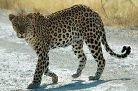
The animals of the velds are primarily lions, leopards, cheetah and kudu.
* People
(i) Known for cattle rearing and mining.
(ii) The soils are not very fertile in the velds due to the presence of discontinuous grasses exposing barren surface. The main crops are maize, wheat, barley, oats and potato. Cash crops like tobacco, sugarcane and cotton are also grown.
(iii) Sheep rearing is the most important occupation of the people. Sheep is reared mainly for wool and has given rise to the wool industry in the velds. Merino sheep is a popular species and their wool is very warm.
(iv) Dairy farming is the next important occupation. Cattle are reared in the warmer and wetter regions and the dairy products like butter, cheese are produced for both domestic supply and also for export.
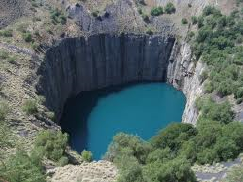
(v) The velds have rich reserve of minerals:-
(a) Iron and Steel industry has developed where coal and iron are present.
(b) Gold and diamond mining are major occupations of people of this region.
(c) johannesburg is know for being the gold capital of the world.
(d) Kimberley is famous for its diamond mines.
(e) Mining of diamond and gold in South Africa led to the establishment of trade ties with Britain and gradually South Africa became a British Colony.
(f) This mineral rich area has a well-developed network of transport
Chapter 8: Human Environment Interactions – The Tropical and the Subtropical Region
- Books Name
- CBSE Class 7 Social Science Book
- Publication
- Param Publication
- Course
- CBSE Class 7
- Subject
- Social Science
* Introduction
The chapter deals with the life of the people and their culture and economic activities in the tropical and subtropical regions. We can find out the role of forests and the land in the economic life of the people living in these areas.
* Life in the Amazon Basin
(i) Notice that the tropical region lies very close to the equator, between 10°N and 10°S. So, it is referred to as the equatorial region.
(ii) The river Amazon flows through this region. It flows from the mountains to the west and reaches the Atlantic Ocean to the east.
(iii) The place where a river flows into another body of water is called the river’s mouth.
(iv) Numerous tributaries join the Amazon River to form the Amazon Basin.
(v) The river basin drains portions of Brazil, parts of Peru, Bolivia, Ecuador, Columbia and a small parts of Venezuela.
(vi) Amazon river basin is the largest river basin in the world.
* Climate
(i) Has hot and wet climate throughout the year.
(ii) Both day and nights are almost equally hot and humid.
(iii) Day temperatures are high with very high humidity.
(iv) In night the temperature goes down but the humidity remains high.
* Rainforests
(i) Due to heavy rains thick forests grow.
(ii) The ground remains dark and damp because forest are so dense that “roof” created by leaves and branches does not allow the sunlight to reach the ground.
(iii) Only shade tolerant vegetation may grow.
(iv) Orchids, bromeliads (special plants which store water in their leaves) grow as plant parasites.
(v) Rich in fauna such as toucans humming birds, bird of paradise with their brilliantly coloured plumage and oversized bills.
(vi) Also animals like monkeys, sloth and ant-eating tapirs are found here. Various species of reptiles and crocodiles, snakes also thrive in these jungles.
(vii) It is also home to many insects and fishes including flesh eating Piranha fish.
* People of the Rainforests
(A) ⇒ People grow most of their food in small areas after clearing some trees in the forest. While men hunt and go for fishing along the rivers, women take care of the crops.
⇒ They mainly grow tapioca, pineapple and sweet potato. As hunting and fishing are uncertain it is the women who keep their families alive by feeding them the vegetables they grow.
⇒ They practice “slash and burn agriculture”. The staple food is manioc, also known as cassava that grows under the ground like the potato. They also eat queen ants and egg sacs. Cash crops like coffee, maize and cocoa are also grown.
(B) The rainforests provide a lot of wood for the houses. Some families live in thatched house shaped like beehives. There are other large apartment-like houses called “Maloca” with a steeply slanting roof.
(C) Life of the people of the Amazon basin is slowly changing. In the older days the heart of the forest, could be reached only by navigating the river. In 1970 the Trans Amazon highway made all parts of the rainforest accessible. Aircrafts and helicopters are also used for reaching various places. The indigenous population was pushed out from the area and forced to settle in new areas where they continued to practice their distinctive way of farming.
(D) The development activities are leading to the gradual destruction of the biologically diverse rainforests. It is estimated that a large area of the rainforest has been disappearing annually in the Amazon basin. The topsoil is washed away as the rains fall and the lush forest turns into a barren landscape.
* Life in the Ganga-Brahmaputra Basin
(i) This basin lies in the sub-tropical region that is situated between 10°N to 30°N latitudes.
(ii) The tributaries of rivers Ganga like the Ghagra, the Son, the Chambal, the Gandak, the Kosi and the tributaries of Brahmaputra drain forming the Ganga-Brahmaputra basin in the Indian subcontinent.
(iii) The main features of this basin are the plains of the Ganga and the Brahmaputra, the mountains and the foothills of the Himalayas and the Sundarbans delta. Also the Ox-bow lakes dot the plain area.
(iv) The area is dominated by monsoon climate which brings rains from mid-June to mid-September. The summers are hot and the winters cool.
(v) Therefore less number of people lives in the mountain area of the Ganga-Brahmaputra Basin because the mountain areas with steep slopes have inhospitable terrain.
(vi) The plain area provides the most suitable land for human habitation because the soil is fertile and agriculture is the main occupation of the people.
(vii) The main crop is paddy. Other crops grown include wheat, maize, sorghum, gram and millets.
(viii) Cash crops like sugarcane and jute are also grown.
(ix) Banana plantations are seen in some areas of the plain.
(x) Other plantation includes tea (in West Bengal and Assam).Silk is produced through the cultivation of silk worms in parts of Bihar and Assam.
(xi) In the ganga and Brahmaputra plain tropical deciduous trees grow, along with teak, sal and peepal. Thick bamboo groves are common in the Brahmaputra plain. The delta area is covered with the mangrove forests. In parts of Uttaranchal, Sikkim and Arunachal Pradesh, Coniferous trees like pine, deodar and fir can be seen because the climate is cool and the slopes are steep.
(xii) Elephants, tigers, deer and monkeys are common in basin. The one-horned rhinoceros is found in the Brahmaputra plain. In the delta area, Bengal tiger, crocodiles and alligator are found. Aquatic life abounds in the fresh river waters, the lakes and the Bay of Bengal Sea. The most popular varieties of the fish are the rohu, catla and hilsa.
(xiii) Fish and rice is the staple diet of the people living in the area.
(xiv) The cities of Allahabad, Kanpur, Varanasi, Lucknow, Patna and Kolkata all with the population of more than ten lakhs are located along the river Ganga. The wastewater from these towns and industries is discharged into the rivers. This leads to the pollution of the rivers.
(xv) All the four ways of transport are well developed in the Ganga-Brahmaputra basin. In the plain areas the roadways and railways transport the people from one place to another. The waterways, is an effective means of transport particularly along the rivers. Kolkata is an important port on the river Hooghly. The plain area also has a large number of airports.
(xvi) Tourism is another important activity of the basin. Taj Mahal on the banks of river Yamuna in Agra, Allahabad on the confluence of the rivers Ganga and Yamuma, Buddhists stupas in Uttar Pradesh and Bihar, Lucknow with its Imambara, Assam with Kaziranga and Manas with wild life sanctuaries and Arunachal Pradesh with a distinct tribal culture are some of the places worth a visit.
* Interesting Facts:
1. Spanish explorers discovered Amazon river and were attacked by a group of local tribes wearing headgears and grass skirts. These people reminded them of the fierce tribes of women warriors known in ancient Roman Empire as the Amazons. Hence named Amazon.
2. Tributaries: These are small rivers that join the main river. The main river along with all its tributaries that drain an area form a river basin or the catchment area.
3. Slash and Burn is a way of cultivating land where farmers clear a piece of land by slashing or cutting down trees and bushes which are burnt, and releases the nutrients into the soil. Crops are now grown in this cleared field for a few years. After repeatedly using the patch of land, the soil loses its nutrients. So it is abandoned. Then they clear another plot of land to plant. In the mean time young trees grow in the old field. In this way soil fertility is restored. People can then return to it and start cultivating it again.
4. Population density: It means the number of persons that live in one sq. km of area e.g. the population density of Uttaranchal is 159 while the density of West Bengal is 904 and that of Bihar is 880.
5. Terraces are built on steep slopes to create flat surfaces on which crop are grown. The slope is removed so that water does not run off rapidly.
6. In the fresh waters of River Ganga and River Brahmaputra, a variety of dolphin locally called Susu (also called blind dolphin) is found. The presence of Susu is an indication of the health of the river. The untreated industrial and urban wastes with high amount of chemicals are killing this species.
* A case study
Lake : A source of Livelihood
Binod is a fisherman living in the Matwali Maun village of Bihar. He is a happy man today. With the efforts of the fellow fisherman - Ravindar, Kishore, Rajiv and others, he cleaned the maun or the ox-bow lake to cultivate different varieties of fish. The local weed (vallisneria, hydrilla) that grows in the lake is the food of the fish. The land around the lake is fertile. He sows crops such as paddy, maize and pulses in these fields. The buffalo is used to plough the land. The community is satisfied. There is enough fish catch from the river-enough fish to eat and enough fish to sell in the market. They have even begun supply to the neighbouring town. The community is living in harmony with nature. As long as the pollutants from nearby towns do not find their way into the lake waters, the fish cultivation will not face any threat.
Chapter 7: Human Environment – Settlement, Transport and Communication
- Books Name
- CBSE Class 7 Social Science Book
- Publication
- Param Publication
- Course
- CBSE Class 7
- Subject
- Social Science
* INTRODUCTION
Early human beings depended entirely on nature for food, clothing and shelter; but with time they learnt now skills to grow food, build homes and develop better means of transport and communication. In this way they modified the environment where they lived
The place where a building or a settlement develops is called its site.
The natural conditions for selection of an ideal site are-
(A) Favourable climate (B) Availability of water
(C) Suitable land (D) Fertile soil.
* Settlements
1. Settlements are places where people build their homes. Early human beings lived on trees and in caves. When they started to grow crops it became necessary to have a permanent home. The settlements grew near the river valleys as water was available and land was fertile. With development of trade, commerce and manufacturing, human settlements became larger. Settlement flourished and civilizations developed near river valleys.
2. Settlements can be permanent or temporary. Settlements which are occupied for a short time are called temporary settlements. The people living in a deep forests, hot and cold deserts and mountains often dwell in such temporary settlements. They practice hunting, gathering and shifting cultivation. However more and more settlements today are permanent settlements. In these settlements, people build permanent homes to live in.
3. There are two different types of permanent settlements - the rural and the urban settlements. The villages are rural settlement where people are engaged in activities like agriculture, fishing, forestry, crafts work and trading etc. Rural settlements can be compact or scattered. A compact settlement is a closely built area of dwellings, wherever flat land is available. In a scattered settlement dwelling are spaced over an extensive area. This type of settlement is mostly found in hilly tracts, thick forests, and regions of extreme climate.
4. Transhumance is a seasonal movement of people. People who rear animals move in search of new pastures according to changes in seasons.
5. In rural areas, people build house to suit their environment. In regions of heavy rainfall, they have slanting roofs. Places where water accumulates in the rainy season the houses are constructed on a raised platform or stilts.
6. Thick mud walled houses with thatched roofs are very common in areas of hot climate. Local materials like stones, mud, clay, straw etc are used to construct houses.
7. The towns are small and the cities are larger urban settlements. In urban areas the people are engaged in manufacturing, trading and services.
* TRANSPORT
General Introduction
1. Transport is the means by which people and goods move. In the early days it took a great deal of time, to travel long distances. People had to walk and use animals to carry their goods. Invention of the wheel made transport easier.
2. With the passage of time different means of transport developed but even today people use animals for transport.
3. In our country donkeys, mules, bullocks and camels are common. In the Andes Mountains of South America, Ilamas are used, as are yaks in Tibet.
4. The early traders from other countries used to take several months to reach India. They took either the sea route or the land route.
5. Aeroplanes have made travel faster. Now it takes only 6-8 hours to travel from India to Europe. Modern means of transport thus saves time and energy.
6. The four major means of transport are roadways, railways, waterways and airways.
* MEANS OF TRANSPORT
ROADWAYS
1. The most commonly used means of transport especially for short distance are roads. They can be metalled (pucca) and unmetalled (kutcha). The plains have a dense network of roads. Roads have also been built in terrains like deserts, forests and even high mountains.
2. Manali - Leh highway in the Himalayan Mountains is one of the highest roadways in the world. Roads built underground are called subways/under paths. Flyovers are built over raised structures.
Railways
1. The railways carry heavy goods and people over long distances quickly and cheaply. The invention of the steam engine and the Industrial Revolution helped in speedy development of rail transport. Diesel and electric engines have largely replaced the steam engines.
2. In places super fast trains have been introduced to make the journey faster. The railway network is well developed over the plain areas. Advanced technological skills have enabled laying of railway lines in difficult mountain terrains also. But these are much fewer in number. Indian railway network is well developed. It is the largest in Asia.
3. The Trans - Siberian Railways is the longest railway system connecting St. Petersburg in Western Russia to Vladivostok on the Pacific coast.
Waterways
1. Waterways were used for transportation since early days. Waterways are the cheapest for carrying heavy and bulky goods over distances. They are mainly of two types - inland waterways and sea routes.
2. Navigable rivers and lakes are used as inland waterways. Some of the important inland waterways are the Ganga - Brahmaputra river system, the Great Lakes in North America and the river Nile in Africa.
3. Sea routes and oceanic routes are mostly used for transporting merchandise and goods from one country to another. These routes are connected with the ports.
4. Some of the important ports of the world are Singapore and Mumbai in Asia, New York, Los Angeles in North America, Rio De Janerio in South America, Durban and Cape Town in Africa, Sydney in Australia, London and Rotterdam in Europe.
Airways
1. This is the fastest way of transport developed in the early twentieth century. It is also the most expensive due to high cost of fuels. Air traffic is adversely affected by bad weather like fog and storms.
2. It is the only mode of transport to reach the most remote and distant areas especially where there are no roads and railways.
3. Helicopters are extremely useful in most inaccessible areas and in time of calamities for rescuing people and distributing food, water, clothes and medicines.
4. Some of the important airports are Delhi, Mumbai, New York, London, Paris, Frankfurt and Cairo.
* COMMUNICATION
MEANING AND TYPES
1. Communication is the process of conveying messages to others. With the development of technology humans have devised new and fast modes of communication.
The process of communication always contains message that are transmitted between sender and receiver. The sender sends the message & the receiver receives it. The receiver understands the message and gives a response which is called as the reply.
2. The advancement in the field of communication system has brought about an information revolution in the world. Different modes of communication are used to provide information, to educate as well as to entertain. Through newspapers radio and television we can communicate with a large number of people. They are therefore called mass media.
3. The satellites have made communication even faster. Satellites have helped in oil survey of ores, underground water, mineral wealth, weather forecast and disaster warning. Now we can send electronic mails or e-mails through Internet. Wireless telephonic communications through cellular phones have become very popular today. Internet not only provides us with worldwide information and interaction but has also made our lives more comfortable. Now we can reserve tickets for railways, airways and even cinemas and hotels sitting at home.
4. With this kind of inter connectivity of people services and institutions across the world, we are a large global society.
New Terms
Settlement : Place where people build their homes.
Transhumance : It is a seasonal movement of people. People who rear animals move in search of new pastures according to changes in seasons.
Compact Settlements : The closely build areas of dwellings.
Transport : It means movement of people and goods from one location to another Eg. rail, air, road, water, cable, pipeline & space
Communication : A process whereby meaning is defined as shared between living organisms. E.g. radio, television, internet, phone, etc. are means of communication.
Industrial Revolution : Industrial Revolution was a period from 18th to 19th century where major changes in agriculture, manufacturing, mining, transportation & technology had a profound effect on the socioeconomic & cultural conditions
of the times. It began in UK, subsequently spread throughout Europe, North America and eventually the world.
Metalled Road : The road having stones chippings mixed with tar to form the road surfacing.
* THINGS TO KNOW
- Settlements are of various types which are found in rural and urban areas like compact, scattered, circular, linear and radial settlements found in rural areas.
- Urban settlements may vary on the basis of population, types of activities, administrative set up & land use.
- Telegram is a form of written communication by which message are sent quickly to distant places. They can be sent as ordinary or express. Express telegrams travel faster then the ordinary telegram.
- Telephone a form of oral communication is widely used these days. STD (Subscriber Trunk Dialling) and ISD (International Subscriber Dialling) Facilities are available on it. Mobile phones are an improvement over fixed line telephone. SMS (Short Messaging Service) and MMS (Multimedia Messaging Services) are sent through it.
- Other means of communication include telex which is a means of printed communication using teleprinter.
- Fax or facsimile is an electronic device, enables instant transmission of any matter, which may be handwritten or printed.
- Voice mail is a computer based system for receiving & responding to incoming telephone calls.
- Pager is an instrument which can be used to receive any short message from the sender at any time.
- Teleconferencing is a system through which people interact with each other without physically sitting in front of other.
- Communication helps us in a number of ways. It is used in business, coordinating function, internal security, secure.
Chapter 6: Natural Vegetation and Wildlife
- Books Name
- CBSE Class 7 Social Science Book
- Publication
- Param Publication
- Course
- CBSE Class 7
- Subject
- Social Science
* INTRODUCTION
Natural vegetation refers to a plant community which has grown naturally without human aid and has been left undisturbed by humans for a long time.
(i) Our country India is one of the twelve mega-bio-diversity countries of the world.
(ii) There are about 47,000 plant species.
(iii) There are about 15,000 flowering plants.
(iv) India also has 89,000 species of animals as well as a rich variety of fish in its fresh and marine water.
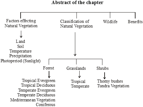
* Factors Effecting Natural Vegetation
(i) The growth of vegetation depends on temperature and moisture.
(ii) It also depends on factors like slope and thickness of soil.
(iii) The type and thickness of natural vegetation varies from place to place because of the variation in these factors.
* Land
(i) The nature of land influences the type of vegetation. The fertile level is generally devoted to agriculture.
(ii) The undulating and rough terrains are areas where grassland and woodlands develop and give shelter to a variety of wild life.
* Soil
(i) Different types of soils provide basis for different types of vegetation.
(ii) The sandy soils of the desert support cactus and thorny bushes while wet, marshy, deltaic soils support mangroves and deltaic vegetation.
* Temperature
(i) The character and extent of vegetation are mainly determined by temperature.
(ii) On the slopes of the Himalayas and the hills of the Peninsula above the height of 915 metres, the fall in the temperature affects the types of vegetation and its growth.
* Precipitation
Areas of heavy rainfall have more dense vegetation as compared to other areas of less rainfall.
* Photoperiod (Sunlight)
The variation in duration of sunlight effects the vegetation. Due to longer duration of sunlight, trees grow faster in summer.
Natural vegetation is generally classified into three broad categories as follows :
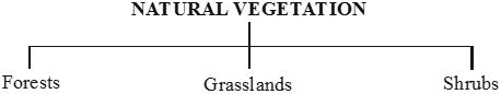
Forests: Grow where temperature and rainfall are plentiful to support a tree cover. Depending upon these factors, dense and open forests are grown.
Grasslands: Grow in the region of moderate rain.
Shrubs: Thorny shrubs and scrubs grow in the dry region.
The changes in the type of natural vegetation occur mainly because of the changes of climatic condition.
* Forests
* Tropical Evergreen Fores
Location:
These forests are also called tropical rainforests. These thick forests occur in the regions near the equator and close to the tropics in the Amazon basin, Zaire basin, Malaysia, Myanmar, Kampuchea, Vietnam, Indonesia.
Characteristics:
(i) These regions are hot and receive heavy rainfall throughout the year. As there is no particular dry season, the trees do not shed their leaves altogether. This is the reason they are called evergreen. These forests trees reach great heights up to 60 metres.
(ii) The thick canopies of the closely spaced trees do not allow the sunlight to penetrate inside the forest even in the day time.
(iii) There are no pure stands of trees but all the species are intermixed which make Commercial Exploitation of these forests very difficult.
Important trees:
Hardwood trees like rosewood, ebony, mahogany are common here.
Animals and Birds found in these forests are elephants, monkey, lemur and deer, one horned rhinoceros, Bats, sloth, scorpions and snails.
* Tropical Deciduous Forests
Location:
Tropical deciduous are the monsoon forests found in the large part of India, northern Australia and in central America.
Characteristics:
(i) These regions experience seasonal changes. Trees shed their leaves in the dry season to conserve water.
(ii) These forests consist of trees with High Commercial Value. These forests are not very dense and the trees are of medium height.
(iii) Hardwood trees are extremely useful for making furniture, transport and constructional materials.
Important trees:
The hardwood trees found in these forests are sal, teak, neem and shisham.
Animals:
Tigers, lions, elephants, langoors and monkeys are the common animals of these regions.
* Temperate Evergreen Forests
Location:
The temperate evergreen forests are located in the mid-latitudinal coastal region. They are commonly found along the eastern margin of the continents, e.g., in south east USA, South China and in South East Brazil.
Characteristics:
These forests have a Mixed Variety of trees. The Timber from these forests is valuable.
Important trees:
They comprise both hard and soft wood trees like oak, pine, eucalyptus, etc.
Animals:
The people living in these parts of the world rear cattle, pigs and sheep - largely for wool, meat and skins.
* Temperate Deciduous Forest
Location:
Forest are found in the north eastern part of USA, China, New Zealand, Chile and also found in the coastal regions of Western Europe.
Characteristics:
(i) The cool climate of this region is favourable for the forest growth. The trees are generally Deciduous in nature. Most of the trees have thick trunks and broad leaves.
(ii) They shed their leaves in autumn and remain leafless during winter.
Important Trees and Animals:
The common trees are oak, ash, beech, etc. Deer, foxes, wolves are the animals commonly found. Birds like pheasants and monals are also found here.
* Mediterranean Vegetation
Location:
(i) The west and south west margins of the continents have Mediterranean vegetation.
(ii) It is mostly found in the areas around the Mediterranean Sea in Europe, Africa and Asia, hence the name.
(iii) This kind of vegetation is also found outside the actual Mediterranean region in California in the USA, south west Africa, south western South America and South west Australia.
Characteristics:
(i) These regions are marked for hot dry summers and mild rainy winters.
(ii) Citrus fruits such as oranges, figs, olives and grapes are commonly cultivated here because people have removed the natural vegetation in order to cultivate what they want to. There isn’t much wildlife here.
(iii) The trees have broad leaves and are widely spaced. They are not thick and luxuriant. They are not very tall. The trees have adapted themselves to the long dry summer season.
* Coniferous Forests
Location:
In the higher latitudes (50° - 70°) of Northern hemisphere the spectacular Coniferous forests are found. These are also called as Taiga. These forests are also seen in the higher altitudes. These are the trees which Salima found in the Himalayas in abundance.
Uses of Trees:
They are tall, softwood evergreen trees. These woods are very useful for making pulp, which is used for manufacturing paper and newsprint. Match boxes and packing boxes are also made from softwood.
Important trees and Animals:
Chirr, pine, cedar are the important variety of trees in these forests. Silver fox, mink, polar bear are the common animals found here.
* Grasslands
* Tropical grasslands
Location:
These grow on either side of the equator and extend till the tropics.
Characteristics:
(i) This vegetation grows in the areas of moderate to low amount of rainfall. They can grow very tall, about 3 to 4 metres in height. Savannah grasslands of Africa are of this type.
(ii) The Tall and Thick Grass grows here with Scattered Trees. Cattle rearing is carried out on these grasslands.
Animals:
Elephants, zebras, giraffes, deer, leopards are common in tropical grasslands.
* Temperate grasslands
Location:
These are found in the mid-latitudinal zones and in the interior part of the continents.
Characteristics:
(i) These grasslands are known by different local names, such as Prairies in North America, Pampas in Argentina, Veld in South Africa, Steppes in Russia and Downs in Australia.
(ii) These areas do not get sufficient amount of rainfall that is why Short Grass grows here with Scattered Trees. Cattle are reared in these grasslands. Usually, grass here is short and nutritious.
Animals:
Wild buffaloes, bisons, antilopes are common in the temperate region.
* Desert Vegetation (Shrubs)
* Thorny bushes
Location:
These are found in the dry desert like regions. Tropical deserts are located in the western margins of the continents.
Characteristics:
(i) The vegetation cover is scarce here because of scanty rain and scorching heat.
(ii) Truly speaking, there are no forests here. Only the Xerophytes, the plants which adapt themselves to the hot and dry climate, are available.
Important Trees and Animals:
Palm, Cactus and thorny bushes are found here. Camel, Hyena, Fox, Jackal, Wild asses, Reptiles, Lizards, Snakes are the animals common in desert.
* Tundra Vegetation
Location:
This vegetation is found in the polar areas of Europe, Asia and North America.
Characteristics:
(i) The polar region is extremely cold. The growth of natural vegetation is very limited here.
(ii) Only mosses, lichens and very small shrubs are found here. It grows during the very short summer. This is called Tundra type of vegetation. The animals have thick fur and thick skin to protect themselves from the cold climatic conditions.
Animals:
Seal, Walruses, Musk-oxen, Arctic Owl, Polar Bear and Snow Foxes are some of the animals found here.
* Benifits
(i) Forests are very useful for us. They perform various functions. Plants release oxygen that we breathe and absorb carbon dioxide.
(ii) The roots of the plants bind the soil, thus, they control soil erosion.
(iii) Forests provide us with timber for furniture, fuel wood, fodder, medicinal plants and herbs, lac, honey, gum, etc. Forests are the natural habitat of wild life.
* Facts to Know
(i) The tropical evergreen forest in Brazil is so enormous that it is like the lungs of the earth:
(ii) Anaconda, one of the world’s largest snakes is found in the tropical rainforest. It can kill and eat a large animal such as a crocodile.
(iii) Mediterranean trees adapt themselves to dry summers with the help of their thick barks and wax coated leaves which help them reduce transpiration.
(iv) Mediterranean regions are known as ‘Orchards of the world’ for their fruit cultivation.
(v) Taiga means pure or untouched in the Russian language.
(vi) Grasslands are known by different names in different regions.
(vii) Tropical Grasslands East Africa- Savanna Brazil- Campos Venezuela- Llanos
(viii) Temperate Grasslands Argentina- Pampas N. America- Prairie S. Africa- Veld C. Asia- Steppe Australia- Down.
Illustration 1
Name the areas of tropical evergreen forests and explain why their commercial exploitation is difficult.
Solution
These thick forests occur in the regions near the equator and close to the tropics in the Amazon baisn, Zaire basin, Malaysia, Myanmar, kampuchea, Vietnam, Indonesia. There are no pure stands of trees but all the species are intermixed which make Commercial Exploitation of these forests very difficult.
Illustration 2
What are the local names given to temperate grasslands ?
Solution
These grasslands are known by different local names, such as Prairies in North America, Pampas in Argentina, Veld in South Africa, Steppes in Russia and Downs in Australia.
Chapter 5: Water
- Books Name
- CBSE Class 7 Social Science Book
- Publication
- Param Publication
- Course
- CBSE Class 7
- Subject
- Social Science
* INTRODUCTION
Our earth is like a terrarium. The same water that existed centuries ago still exists today. Water is found in abundance on the earth. It covers about three forth of the earth surface as such the earth appears blue from space and hence called a blue planet.
The major sources of fresh water are the rivers, ponds, springs and glaciers. The ocean bodies and the seas contain salty water. The water of the oceans is salty or saline as it contains large amount of dissolved salts. Most of the salt is sodium chloride or the common table salt that we eat.
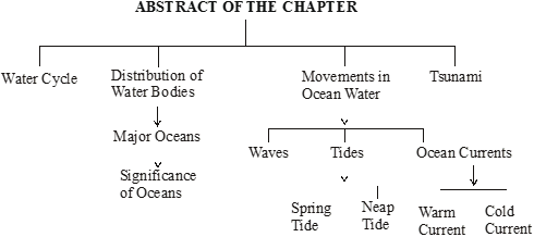
* Water Cycle
The sun’s heat causes evaporation of water vapour. When the water vapour cools down, it condenses and forms clouds. From there it may fall on the land or sea in the form of rain, snow or sleet.
The process by which water continually changes its form and circulates between oceans, atmosphere and land is known as the Water Cycle
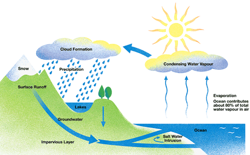
* Distribution of Water Bodies
We all know that three-fourth of the earth surface is covered by water. About 97% of the earth's total water is in oceans and sea. It is salty and unsuitable for consumption. Another two percent water is contained in Ice-caps and glaciers. Only one percent is fresh water which is available and is suitable for human use.
Distribution of water bodies
Oceans : 97.3 - Saline water
Ice-caps : 02.0
Ground water : 0.68
Fresh water lakes : 0.009
Atmosphere : 0.0019
Rivers : 0.0001
Inland seas and salt lakes : 0.009
100.00
* Major Water Bodies
There are four major oceans on the Earth They are:
Pacific Ocean
This is the largest ocean. It is roughly triangular. It covers nearly 1/3 of the Earth’s surface. The average depth of this ocean is 4572 metres. But this is the deepest ocean and the deepest point in this ocean is Mariana Trench, which is 11,033 metres deep from the sea level.
Atlantic Ocean
Atlantic Ocean is almost half the size of the Pacific Ocean. It is S-Shaped and it covers nearly 1/6th of the Earth’s surface. This ocean has a number of islands and marginal seas. It provides busy transport routes between North America and Europe.
Indian Ocean
Indian Ocean is often called as Half An Ocean It is encircled by Africa, Asia and Australia. It is a small ocean and does not open northwards. The average depth of this ocean is 4,000 metres but Sunda Trench, the deepest point of this ocean, is 7,450 metres deep from the sea level.
Arctic Ocean
Arctic ocean is located around the North Pole to the north of Europe, Asia and Canada. Most of this ocean is frozen. This ocean covers an area of 13 million sq.kms.
Southern Ocean
This is a large water body which is around the Antarctic continent. It merges with pacific, Atlantic and Indian Ocean.
* Significance of Oceans
Oceans play a dominant role in order to control all types of life on Earth.
1. They are the main source of humidity in the atmosphere which brings rainfall.
2. They are the storehouse of minerals.
3. They exercise a direct control over the temperature on the oceans and along the coastal landmass.
4. They provide food like fish to us.
5. They are used as highways of trade and commerce.
6. They have the enormous potential to generate energy from tidal waves.
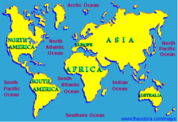
Illustration-1
Explain the Hydrological Cycle (Water Cycle).
Sol. The sun’s heat causes evaporation of water vapour. When the water vapour cools down, it condenses and forms clouds. From there it may fall on the land or sea in the form of rain, snow or sleet.
The process by which water continually changes its form and circulates between oceans, atmosphere and land is known as the Water Cycle Or Hydrological Cycle
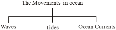
* Ocean Circulation
Unlike the calm waters of ponds and lakes, ocean water keeps moving continuously. It is never still. The movements that occur in oceans can be broadly categorised as : waves, tides and currents.
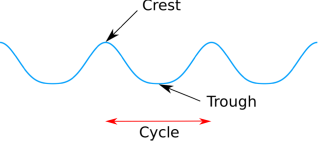
Waves
When the wind comes in contact with the sea water, it pushes the water of the sea surface in the direction in which it blows. Thus water particles start moving up and down in the direction of wind forming curls in water. These curls form a Wave. Thus when the water on the surface of the ocean rises and falls alternately, they are called waves.
A wave has two major parts. The upward part is called CREST and the downward part is called TROUGH.
Some waves however are caused by submarine earthquakes or landslides into water bodies. Tsunamis are such big waves.
Tsunami - The earth’s Pandemonium
Tsunami or the harbour wave struck havoc in the Indian Ocean on the 26 December 2004. The wave was the result of the earthquake that had its epicenter close to the western boundary of Sumatra. The magnitude of the earthquake was 9.0 on the Richter scale.
Occurrence: As the Indian plate went under the Burna plate, there was a sudden movement of the sea floor, causing the earthquake. The ocean floor was displaced by about 10 -20m and tilted in a downwardly direction. After thrusting of the Indian plate below the Burma plate, the water mass rushed back towards the coastline. Tsunami travelled at a speed of about 800km. per hour.
Affected Area: Tsunami waves travelled upto a depth of 3 km. from the coast killing more than 10,000 people and affected more than lakh of houses. In India, the worst affected were the coastal areas of Andhra Pradesh, Tamil Nadu, Kerala, Pondicherry and the Andaman and Nicobar Islands. Indonesia, Malaysia, Thailand, Sri Lanka, Myanmar, India, Maldives, Somalia and Tanzania were also affected.
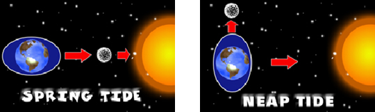
Tides
The rhythmic rise and fall of ocean water twice in a day is called a tide. It is a high tide when water covers much of the shore by rising to its highest level. It is low tide when water falls to its lowest and recedes from the shore.
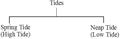
The strong gravitational pull exerted by the sun and the moon on the earth’s surface causes the tides. The water of the earth closer to the moon gets pulled under the influence of the moon’s gravitational force and causes high tide.
Spring Tide: During the full moon and new moon days, the sun, the moon and the earth are in the same line and the tides are highest. These tides are called spring tides.
Neap Tide: When the moon is in its first and last quarter, the ocean waters get drawn in diagonally opposite directions by the gravitational pull of sun and earth resulting in low tides. These tides are called neap tides.
Uses of Tides :
(i) High tides help in navigation. They raise the water level close to the shores. this helps the ships to arrive at the harbour more easily.
(ii) The high tides also help in fishing. Many more fish come closer to the shore during the high tide. This enables fishermen to get a plentiful catch.
(iii) The rise and fall of water due to tides is being used to generate electricity in some places.
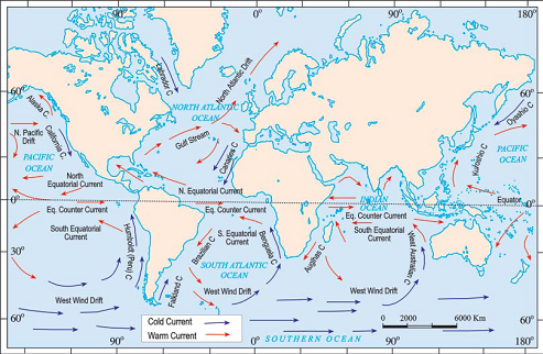
* Ocean currents
Ocean currents are streams of water flowing constantly on the ocean surface in definite directions. The ocean currents may be warm or cold.
The ocean currents originate due to :
(i) Difference in density of sea water.
(ii) The rotation of the earth.
(iii) The planetary winds.
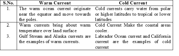
Uses of Ocean Currents :
1. Climate of coastal regions and islands is influenced by the nature of ocean current.
2. Rainfall is often caused by currents.
3. Meeting of warm & cold current leads to ideal condition of fishing.
4. Ocean currents helps in Navigation.
5. The areas where warm and cold current meet also make weather foggy which makes navigation difficult.
* Glossary
Terrarium : It is an artificial enclosure for keeping small house plants.
Hydrosphere : All the water bodies of the Earth’s surface is called hydrosphere.
* Facts to Know
- Salinity is the amount of salt in grams present in 1000 grams of water. The average salinity of the oceans is 35 parts per thousand.
- Dead sea in Israel has salinity of 45 parts per thousand. Swimmers can float in it because the increased salt content make it dense.
- March 22 is celebrated as World Water Day when the need to conserve water is reinforced in different ways.
- Waves are formed when gentle winds scrape across the ocean surface. The stronger the wind blows, the bigger the wave becomes.
- Tsunami is a Japanese word that means “Harbour waves.” as the harbours get destroyed whenever there is tsunami.
Illustration 1
Write any two uses of ocean currents.
Solution
(i) Main source of humidity in the atmosphere which brings rainfall.
(ii) Storehouse of minerals.
Illustration 2
What was the cause of Tsunami that occurred on 26 Dec.2004.
Solution
As the Indian plate went under the Burna plate, there was a sudden movement of the sea floor, causing the earthquake. The ocean floor was displaced by about 10 -20m and tilted in a downwardly direction. After thrusting of the Indian plate below the Burma plate, the water mass rushed back towards the coastline. Tsunami travelled at a speed of about 800km. per hour.
Chapter 4: Air
- Books Name
- CBSE Class 7 Social Science Book
- Publication
- Param Publication
- Course
- CBSE Class 7
- Subject
- Social Science
* INTRODUCTION
Air is a mixture of gases.
It surrounds our Earth.
We cannot perceive it when it is calm, but it is felt when the air is in motion.
The total mass of air surrounding our Earth is called atmosphere.
All living beings on this earth depend on the atmosphere for their survival.
It is held around the Earth because of the Earth’s gravitational force.
The atmosphere comprises of numerous gases, water particles, dust particles etc.
These gases, water particles and dust particles are necessary for the support of our life and that of plants and animals.
We inhale and exhale in this atmosphere.
Water vapour is also necessary for us. It is the source of rainfall without which we cannot live.
Uses of Air : It provides us the air we breathe and protects us from the harmful effects of the sun’s rays. Without this blanket of protection, we would be baked alive by the heat of the sun during day and get frozen during night. So it is this mass of air that has made the temperature on the earth liveable.
Composition : Nitrogen and oxygen are two gases which make up the bulk of the atmosphere. Carbon dioxide, helium, ozone, argon and hydrogen are found in lesser quantities. Apart from these gases, tiny dust particles are also present in the air.
1. (i) Nitrogen is the most plentiful gas in the air. 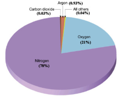
(ii) When we inhale, we take some amount of nitrogen into our lungs and exhale it.
(iii) Plants can not take nitrogen directly from the air.
(iv) Bacteria, that live in the soil and roots of some plants, take nitrogen from the air and change its form so that plants can use it.
2. (i) Oxygen is the second most plentiful gas in the air.
(ii) Humans and animals take oxygen from the air as the breathe.
(iii) Green plants produce oxygen during photosynthesis.
3. (i) Carbon dioxide is another important gas.
(ii) Green plants use carbon dioxide to make their food and release oxygen.
(iii) Humans or animals release carbon dioxide. The amount of carbon dioxide released by humans or animals seems to be equal to the amount used by the plants which make a perfect balance.
* Structure of the Atmosphere
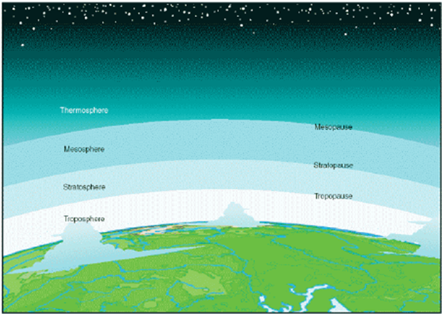
Our atmosphere is divided into five layers starting from the earth’s surface. These are Troposphere, Stratosphere, Mesosphere, Thermosphere and Exosphere.
Troposphere 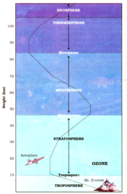
- This layer is the most important layer of the atmosphere.
- It average height is 13 km.
- The air we breathe exists here. Almost all the weather phenomena like rainfall, fog and hailstorm occur in this layer.
Stratosphere
- Above the troposphere lies the stratosphere.
- It extends up to a height of 50 km.
- This layer is almost free from clouds and associated weather phenomenon, making conditions most ideal for flying aeroplanes.
- One important feature of stratosphere is that it contains a layer of ozone gas. It protects us from the harmful effect of the sun rays.
Mesosphere
- This is the third layer of the atmosphere.
- It lies above the stratosphere. It extends up to the height of 80 km.
- Meteorites burn up in this layer on entering from the space.
Thermosphere
- In thermosphere temperature rises very rapidly with increasing height. Ionosphere is a part of this layer.
- It extends between 80 - 400 km. This layer helps in radio transmission. In fact, radio waves transmitted from the earth are reflected back to the earth by this layer.
Exosphere
- The upper most layer of the atmosphere is known as exosphere.
- This layer has very thin air. Light gases like helium and hydrogen float into the space from here.
Illustration
What is the significance of dust particles and water vapour in the atmosphere?
Solution
These gases, water particles and dust particles are necessary for the support of our life and that of plants and animals. We inhale and exhale in this atmosphere. Water vapour is also necessary for us. It is the source of rainfall without which we cannot live.
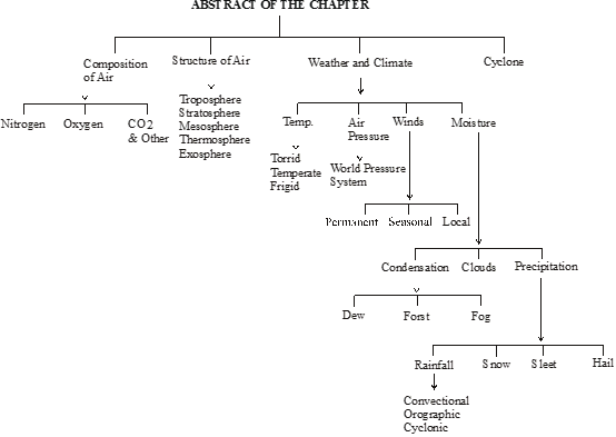
* Weather and Climate
Weather is hour-to-hour, day to day condition of the atmosphere. Weather can change dramatically from day to day. However, the average weather condition of a place for a longer period of time represents the climate of a place.
Temperature
The degree of hotness and coldness of the air is known as temperature. An important factor that influences the distribution of temperature is insolation. Insolation is the incoming solar energy intercepted by the earth.
The amount of insolation decreases from the equator towards the poles. Therefore, the temperature decreases in the same manner. If the earth’s temperature rises too high, It would become too warm for some crops to grow. Temperature in cities is much higher than that of villages. The concrete and metals in buildings and the asphalt of roads get heated up during the day. This heat is released during the night. Also, the crowded high rise buildings of the cities trap the warm air and thus raise the temperature of the cities.
Air Pressure
Air above us presses us with a great force on our bodies. However, we don’t even feel it. This is because the air presses us from all directions and our body exerts a counter pressure.
Air pressure is defined as the pressure exerted by the weight of air on the earth’s surface. As we go up the layers of atmosphere, the pressure falls rapidly. The air pressure is highest at sea level and decreases with height. Horizontally the distribution of air pressure is influenced by temperature of air at a given place. In areas where temperature is high the air gets heated and rises. This creates a low-pressure area. Low pressure is associated with cloudy skies and wet weather.
In areas having lower temperature, the air is cold. It is therefore heavy. Heavy air sinks and creates a high pressure area. High pressure is associated with clear and sunny skies.
The air always moves from high pressure areas to low pressure areas.
Wind
The movement of air from high pressure area to low pressure areas is called wind. Winds can be broadly divided into three types.
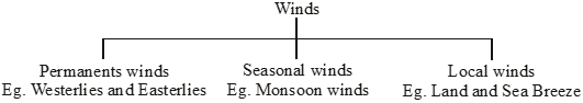
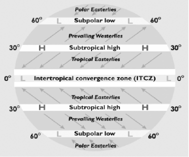
1. Permanent winds: The trade winds, westerlies and easterlies are the permanent winds. These blow constantly throughout the year in a particular direction.
2. Seasonal winds: These winds change their direction in different seasons. For example monsoons in India.
3. Local winds: These blow only during a particular period of the day or year in a small area. For example, land and sea breeze.
Loo: The hot and dry local wind of northern planes of India is called loo.
Moisture
When water evaporates from land and different water bodies, it becomes water vapour. Moisture in the air at any time, is known as humidity. When the air is full of water vapour we call it a humid day. As the air gets warmer, its capacity to hold the water vapour increases and so it becomes more and more humid.
Humidity
The actual amount of water vapour in a given volume of air is known as Total Humidity or Absolute Humidity. The absolute humidity is measured in grams per cubic metre.
The ratio between the actual amount of water vapour present in a given volume of air and the water vapour which the same volume of air can contain till its saturation level is called Relative Humidity. It is measured in terms of percentage.
* Condensation
Due to decrease in temperature the water vapour starts converting into liquid water droplets. This precess is called condensation. Condensation has various forms.
Dew
On cool nights during winter, when the Earth radiates heat and gets cooler, then the air which comes in contact with the cool ground also becomes cooler and water vapour starts condensing over the grass, tree leaves, etc., which could be seen in the early morning. This is called Dew.
Frost
During winter nights, when the temperature becomes very low, often reaching the freezing point, then the water vapour converts into tiny crystals of ice and could be seen as a white sheet on the sand particles, grass and other plants. This is called Frost.
Fog or mist
When the water vapour in the lower atmosphere condenses, but remain suspended in the atmosphere obstructing visibility, it is called FOG. Fog is normally thick with poor visibility. If it is thin with more visibility it is called Mist. Fog or mist normally develops during winter season due to low temperature.
* Precipitation
Precipitation is the process under which the condensed water vapours fall on the ground in various forms such as rain, snow, sleet and hail.
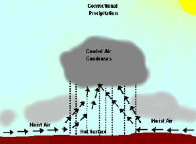
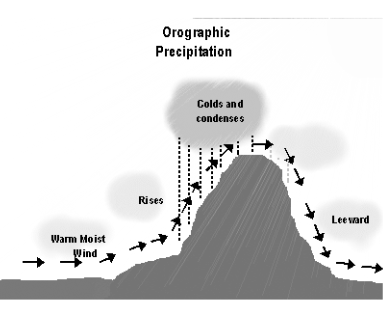
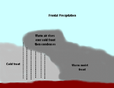
Precipitation that comes down to the earth in liquid form in called rain. On the basis of mechanism, there are three types of rainfall : the convectional rainfall, the orographic rainfall and the cyclonic rainfall.
Convectional Rainfall:
When a warm air motion ascend, its temperature decreases until reaching the dew point (quantity of water vapour that atmosphere can bear to a certain temperature) leading to clouds formation, and subsequent, to precipitation, usually in the form of showers.
Orographic Rainfall:
When an air motion finds out an emphasis ascending area and consequently, reaches the dew point causing clouds. The precipitation occurs by normal processes already explained in previous posts.
Cyclonic or Frontal Rainfall:
When an air motion finds a frontal surface, contact area between two air motions, it is forced to go up causing precipitation by the means described before.
In a warm front, the warm air moves above the cold air, rising up because it is less dense. This causes continuing rain, of great duration and low intensity.
In a cold front the cold air moves under the warmer, forcing it to rise. It causes intense rain, like showers.
Rainfall is very important for the survival of plants and animals. It brings fresh water to the earth’s surface. If rainfall is less - water scarcity and drought occur. On the other hand if it is more, floods take place.
Snow:
When the condensation takes place at about freezing point or a little below the freezing point, then water vapour changes into tiny crystals of ice and fall on the ground in a soft cotton-like structure. This is called Snowfall.
![]()
Sleet:
Sleet is the combined occurrence of rain and snow.
Hail:
When the water droplets of rain happened to pass through a very cold air mass, they freeze into hard pelts of ice and fall on the ground. This is called Hail or Hailstone
Cyclone:
The cyclone originated as a “depression” in the Gulf of Thailand, near east of Port Blair, on 25 October 1999 and gradually moved in a northwestward direction. It intensified into a super cyclone and hit the area between Erasama and Balikuda in Orissa on 29 October at 10.30 a.m.
* Affective Area
The super cyclone swept entire the coast of Orissa including the cities of Bhubaneshwar and Cuttack and 28 coastal towns.
* Effects of Super Cyclone
(i) About 13 million people were affected.
(ii) A large number of livestock were killed.
(iii) Standing crops of paddy, vegetables and fruits were heavily damaged.
(iv) Due to salinisation caused by tidal surge, large tracts of agricultural land have turned infertile.
(v) Large tracts of sal, teak and bamboo plantations have disappeared.
(vi) The mangrove forests between Paradeep and Konark vanished.
* Facts to Know
1. Carbon dioxide released in the atmosphere creates a green house effect by trapping the heat radiated from the earth. It is therefore called a greenhouse gas and without it the earth would have been too cold to live in.
However, when its level in the atmosphere increases due to factory smoke or car fumes, the heat retained increases the temperature of the earth. This is called global warming. This rise in temperature causes the snow in coldest parts of the world to melt. As a result the sea level rises, causing floods in the coastal areas. There may be drastic changes in the climate of a place leading to extinction of some plants and animals in the long run.
2. When air is heated, it expands, becomes lighter and goes up. Cold air is denser and heavy. That is why it tends to sink down. When hot air rises, cold air from surrounding area rushes there to fill in the gap. That is how air circulation takes place.
3. You will be surprised to know that the earth receives only 1 in 2,000,000,0000 parts of the sun’s energy.
4. The standard unit of measuring temperature is degree Celsius. It was invented by Anders Celsius. On the Celsius scale the water freezes at 0°C and boils at 100°C.
5. On the moon there is no air and hence no air pressure. Astronauts have to wear special protective space suits filled with air when they go to the moon. If they did not wear these space suits, the counter pressure exerted by the body of the astronauts would make the blood vessels burst. The astronauts would bleed.
6. A wind is named after the direction from which it blows, e.g. the wind blowing from the west is called Westerly.
Illustration 1
What is the difference between fog and mist ?
Solution
When the water vapour in the lower atmosphere condenses, but remains suspended in the atmosphere obstructing visibility, it is called FOG. Fog is normally thick with poor visibility. If it is thin with more visibility it is called Mist.
Illustration 2
Bring out the relationship between temperature and pressure.
Solution
The temperature of the atmosphere varies from place to place. Whenever there is increase in the temperature of the air, it gets heated and expands in volume and becomes lighter. Due to less weight the heated air rises up causing low pressure. But at high altitude the same air gets cooled and becomes heavier and thus it descends down causing high pressure.
Chapter 3: Our Changing Earth
- Books Name
- CBSE Class 7 Social Science Book
- Publication
- Param Publication
- Course
- CBSE Class 7
- Subject
- Social Science
* Introduction
The lithosphere is broken into a number of plates known as the Lithospheric plates.
These plates move around very slowly – just a few millimetres each year.
This is because of the movement of the molten magma inside the earth. The molten magma inside the earth moves in a circular manner.
The movement of these plates causes changes on the surface of the earth.
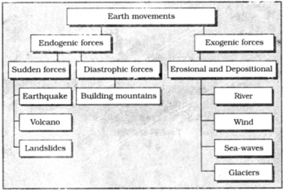
Earth movements : The earth movements are divided on the basis of the forces which cause them. The forces which act in the interior of the earth are called as Endogenic forces and the forces that work on the surface of the earth are called as Exogenic forces.
* Earthquakes 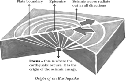
The sudden mild or violent shaking of a part of the earth is called an earthquake. It is generally accompanied by a rumbling sound and tremors.
One of the causes of earthquakes is the movement of the molten rock inside the earth’s crust. Sometimes this molten rock is thrown out and volcanoes are caused. This eruption also causes earthquakes.
Earthquakes occur in places where the earth’s crust is weak.
Violent earthquakes are frequent in areas where there are volcanoes, e.g., the belt surrounding the Pacific Ocean.
The tectonic or horizontal movements of the earth bring about disturbances in its interior portions.
The point where these vibrations originate is called the focus of the earthquake. The point above the focus on the earth’s surface is called the epicentre of the earthquake.
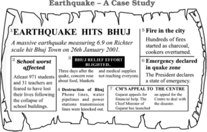
An earthquake lasts for a few seconds, but it causes a huge loss of life and property. In India, earthquakes occur frequently in the areas such as foot-hills of the Himalayas and Ganga-Brahmaputra valley.
The vibration of the earthquakes are recorded by an instrument called Seismograph.
The magnitude of earthquake is measured by Richter Scale.
The number of this scale range from 0 to 9.
Earthquake of magnitude 7 or above are very destructive and cause heavy damage to life and property.
Earthquakes bring about changes on the surface of the earth in a number of ways. They may cause landslides in the hilly areas and cracks in the earth’s crust. In the coastal areas the earthquakes sometimes submerge land or old islands and sometimes they give birth to new ones. Sometimes hidden minerals buried under deep earth reveal themselves on the surface of the earth.
* EARTHQUAKE PREPAREDNESS
Where to take shelter during an earthquake —
Safe Spot – Under a kitchen counter, table or desk, against an inside corner or wall.
Stay Away from – Fire places, areas around chimneys, windows that shatter including mirrors and picture frames.
Be Prepared – Spread awareness amongst your friends and family members and face any disaster confidently.
* Volcanoes 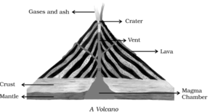
Volcanoes are openings in the earth’s crust through which materials are thrown out from the interior of the earth.
The materials thrown out include hot molten rock or lava along with ash, some solid rock particles, steam and gas.
The opening itself is called a vent around which a conical mountain may be formed.
The funnel-shaped basin surrounding the vent is called a crater.
The liquid of the volcano, so long as it remains within the surface of the earth, is called magma. But when this magma rises slowly to the surface of the earth, it is called lava.
Volcanoes are classified into three types on the basis of their composition and shape. They are :
According to the nature and frequency of eruptions, volcanoes around the world have been divided into three categories:
1. Active volcanoes 2. Dormant volcanoes 3. Extinct volcanoes
Active volcanoes
These erupt quite frequently and are usually found where folding and faulting is active. The crust of the earth in such regions is under tremendous pressure and, therefore, tends to crack. We find a belt of such active volcanoes around the Pacific Ocean, which is called the Ring of Fire. Examples of active volcanoes include Mt Etna in Italy and Barren Island in the Andaman Sea in India. There are about 500 active volcanoes in the world.
Dormant volcanoes
These volcanoes have not erupted for a long time. They are also called sleeping volcanoes as they may erupt though they have not done so in a long time. Mt Vesuvius in Italy is a good example of a dormant volcano. When they come to life, dormant volcanoes can be really destructive.
Extinct volcanoes
These volcanoes are dead and inactive. There is virtually no movement inside such structures. Mt Kilimanjaro in East Africa is one such volcano. The peak of this mountain is now covered with ice. Crater Lake, in Oregon, USA, is another example where a lake has formed in the crater over the years. Such lakes are called Crater Lakes.
* MAJOR LAND FORMS Do you know?
The landscape is being continuously worn away by two processes – weathering and erosion.
Weathering is the breaking up of the rocks on the earth’s surface.
Erosion is the wearing away of the landscape by different agents like water, wind and ice.
The eroded material is carried away or transported by water, wind, etc. and eventually deposited.
This process of erosion and deposition create different landforms on the surface of the earth.
* Work of the River as an Agent of Erosion and Deposition
In view of the change in the water supply and slope of land along the path of the river, the river course is- usually divided into three stages which are known as :
(1) The Upper Course or the Mountain Stage.
(2) The Middle Course or the Plain Stage.
(3) The Lower Course or the Delta Stage.
(1) The Upper Course or the Mountain Stage— In this stage, as the slope of the land is generally very steep, the water of the river rushes down with a great speed. Consequently the river not only erodes its sides and bed but also carries stones and fragments of rocks with it. In this way the river is busy, in its upper course, in erosion and transportation. By eroding its sides and bed it develops gorges, V-shaped valleys, waterfalls and rapids, etc.
(2) The Middle Course or the Plain Stage — In this stage the slope is not so steep. It becomes quite gradual, so the river slows down and becomes fit both for navigation and irrigation. The river, when it overflows its bank, deposits the alluvial sediments, which it brings from the mountains, on both the sides. Thus are formed the flood plains which are often level and very fertile. When the course of a river lies in the flat plain, irregularities of the ground force the river to swing from side to side, thereby making big loops. Such loops formed by the river in the flat plain are called meanders. Due to continuous erosion and deposition along the sides of the Meanders the ends of the meander loop come closer. In due course of time the meander loop cuts off from the river and forms a lake called Ox-bow lake.
Levees: The raised banks of flood plain are called levees.
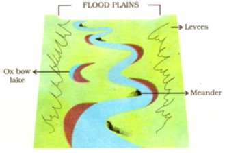
(3) The Lower Course or the Delta Stage —
This is the last stage of the river before it merges into the sea. Its speed now slows down and it becomes quite difficult for it to carry the sediments it had brought with it. So the deposition process begins with a rapid speed. The level of its bed rises and the river gets divided into many channels called distributaries before it falls into the sea. Thus are formed the deltas of the river which contain deposits of alluvium (or soil) and hence they are very fertile.
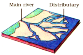
* Work of Sea Waves
The erosion and deposition of the sea waves gives rise to coastal landforms.
Sea waves continuously strikes at the rocks. Cracks develop overtime they become larger and wider.
Thus, hollow like caves are formed on the rocks. They are called Sea caves.
As these cavities become bigger and bigger only the roof of the caves remain, thus forming sea arches.
Further, erosion breaks the roof and only walls are left. These walls like features are called stacks.
The sea rocky coast rising almost vertically above sea water is called sea cliff.
The sea waves deposit sediments along the shores forming beaches.
* Work of Ice
Glaciers are “rivers” of ice which too erode the landscape by bulldozing soil and stones to expose the solid rock below.
Glaciers carve out deep hollows.
As the ice melts they get filled up with water and become beautiful lakes in the mountains.
The material carried by the glacier such as rocks big and small, sand and silt gets deposited. These deposits form glacial moraines.
* Action of Wind
Wind, too, like ice and water, erodes transports and deposits rock materials.
While blowing over land, it lifts and carries fine soil, sand, etc. When the wind slows down, it can no longer carry its entire load, and deposits some of the material it carries.
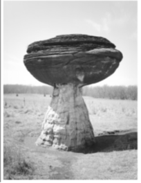
The action of wind is more prominent in arid and semi-arid regions. This is due to several reasons.
• In arid regions, the wind is dry and light, and hence blows at a greater speed. This enables it to erode and carry away more material.
• The lack of trees in these regions means that there are lesser barriers to the flow of air than in areas with trees. This allows winds to flow freely.
• Dry soil is loose, and in the absence of vegetation to hold it down it is easily carried away by the wind.
Wind-blown depressions The blowing away of soil often creates depressions in arid and semi-arid regions. When such a depression becomes deep enough to reach the surface of groundwater, an oasis is formed. The Qattara Depression in the Egyptian desert is an example of an oasis.
Mushroom rocks Winds carry heavier rock fragments at a lower level. So, when wind hits a mass of rock, it tends to erode the lower part of the rock more than the upper part. This gives the rock a shape resembling a mushroom. Such rocks are called mushroom rocks.
Sand dunes When wind laden with sand comes up against an obstacle or its speed drops, it deposits some of the sand it carries. As deposition continues, a small hill of sand, known as a sand dune, is formed.
Sand dunes are generally mobile. They move in the direction of the wind.
When such sand is deposited in large areas, it is called loess.
Large deposits of loess is found in China.
“Do you know”
There are thousands of small waterfalls in the world. The highest waterfall is Angel Falls of Venezuela in South America.
The other waterfalls are Niagara Falls located on the border between Canada and USA in North America and Victoria falls on the border of Zambia and Zimbabwe in Africa.
Chapter 2: Inside Our Earth
- Books Name
- CBSE Class 7 Social Science Book
- Publication
- Param Publication
- Course
- CBSE Class 7
- Subject
- Social Science
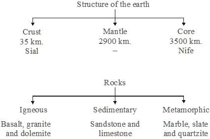
* INTRODUCTION
Our earth is unique as it has all the necessary elements for living beings to exist. The earth comes into existence some five billion years ago. In the beginning, it was extremely hot and molten, but it slowly cooled and acquired the present form. The denser elements, such as iron and nickel gathered in the interior and the lighter ones, such as silicon and aluminium, formed the exterior. Let us take a closer look at the earth’s structure in this chapter.
* STRUCTURE OF THE EARTH
Layers of the Earth
The earth consists of three concentric layers—the crust, the mantle and the core.
The crust
(i) The uppermost layer of the earth is known as the crust.
(ii) The crust is very thin, with an average thickness of about 35 km.
(iii) If we could think of the earth as an egg, the crust could be regarded as the shell. However.
(iv) The crust is not uniformly thick at all places. It is thinner under the oceans and thicker under the continents.
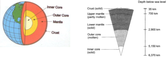
The structure of Earth The layers of the earth
The upper part of the continental crust, which is rich in silica and aluminium, is called sial.
The lower part of the continental crust and the whole of the oceanic crust are composed mainly of denser materials rich in silica and magnesium. They are together called sima.
The surface of the crust is also quite uneven. For example, Mount Everest, the highest mountain peak in the world, is 8,848 metres above sea level, while the world’s deeps point, located in the Mariana Trench in the Pacific Ocean, is 11,034 metres below sea level.
The mantle
(i) Below the crust lies the mantle. It extends up to a depth of about 2,900 km.
(ii) Its chief constituents are silicates of iron and magnesium.
(iii) Both the temperature and the density of the mantle increase with increasing depth towards the centre of the earth.
The mantle has two parts :
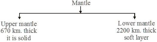
The Core
(i) The innermost layer of the earth is called the core.
(ii) It is about 3,500 km thick.
(iii) It is the densest layer. It is believed to be made up of heavy metals like iron and nickel, and is called nife.
The temperatures at the core are high enough to melt all metals. The study of seismic waves shows that the outer part of the core is molten, while its innermost part is solid.
* The Rocks
(i) The earth’s is made up of rocks. Any natural mass of minerals matter that makes up the earth’s crust is called rock. Rock can be of different colour, size and texture.
(ii) Rocks are made up of minerals.
(iii) Minerals are naturally occurring chemical compounds. The minerals feldspar and quartz (silica) are common constituents of rocks.
(iv) Minerals vary in colour, texture, hardness and lustre.
(v) Diamond is the hardest known mineral. Even some edible substances, like halite, or rock salt, are minerals.
(vi) Some rocks contain useful minerals from which metals, like iron, copper and gold can be extracted. These minerals are called ores. Rocks like marble, granite, basalt and sandstone are good building materials.
(vii) Based on how they were formed, rocks may be of three types—igneous, sedimentary and metamorphic.
Igneous Rocks
(i) Deep below the earth’s surface, rocks are in a molten state called magma.
(ii) When magma cools and solidifies, it forms a very hard rock known as igneous rock (igneous means ‘of fire’).
(iii) Much of the earth’s crust is made up of igneous rocks. Igneous rocks are called primary rocks, as these were the first rocks formed when the earth’s crust solidified.
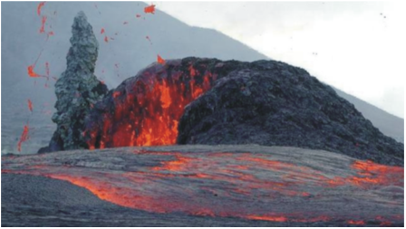
(iv) Igneous rocks are formed either on the surface of the earth or below it.
(v) Extrusive igneous rocks are formed when magma cools and solidifies on reaching the surface. The magma that reaches the surface is known as lava. As the lava cools and solidifies rapidly on the surface, the minerals present in it form very small crystals. Rocks formed in this manner have a fine-grained texture due to the presence of these tiny crystals. The texture, however, is not visible to the naked eye. Basalt, andesite and rhyolite are examples of extrusive igneous rocks.
(vi) Below the earth’s surface, the process of cooling of magma is much slower. The slow cooling allows large crystals of minerals to form. Igneous rocks formed in this way are, therefore, coarse grained. They are known as intrusive igneous rocks. Granite and gabbro are examples of such rocks.
Sedimentary Rocks
(i) Running water, wind and moving ice carry small particles of rock. When these rock particles are deposited on land or on the beds of oceans or rivers, they are called sediments. Sediments are deposited in layers. They harden over the years because of the weight of the layers above and the presence of cementing materials like lime.
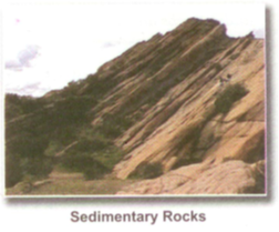
(ii) When the layers are formed under water, the weight of the water also helps in hardening. Rocks formed by the deposition and hardening of layers of sediment are called sedimentary rocks.
(iii) Such rocks are usually made up of layers of different composition. Sandstone, limestone, shale, gravel, clay and conglomerate are examples of sedimentary rocks.
(iv) Coal and Petroleum occurs in sedimentary rocks. Coal and Petroleum has been formed by the decay of plant and animal remains that were buried with sediments millions of years ago.
(v) The remains of plants and animals trapped within layers of rock are called fossils. Hence, petroleum and coal are called fossil fuels.
Metamorphic Rocks
(i) The word ‘metamorphosis’ means change of form. Igneous and sedimentary rocks change their form under very high temperature or pressure. Such ‘changed’ rocks are known as metamorphic rocks.
(ii) Metamorphic rocks are usually very hard. Some common examples of such rocks are marble (formed from limestone), slate (formed from shale), and quartzite (formed from sandstone).
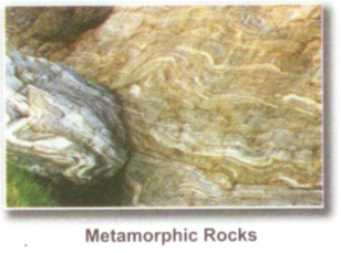
Rocks undergo a cycle of transformation, often called the rock cycle
Magma rising from depths below the earth’s surface produces igneous rocks. The breaking down of different types of rocks produces sediments from which sedimentary rocks are formed. Extreme heat and pressure may cause igneous and sedimentary rocks to form metamorphic rocks. When rocks are melted by heat, new magma is formed.
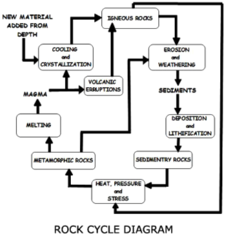
Advantages of Rocks
The study of rocks is called petrology. Rocks can be used for various purposes.
1. As building materials — granite, basalt, sandstone and marble.
2. As fuels — coal and petroleum.
3. As sources of chemicals — potash and phosphates found in sedimentary rocks.
4. As sources of metals — iron, gold and copper from ores.
5. As sources of precious stones — gems and diamonds.
6. Storehouse of fossils.
* Glossary
Crust the uppermost solid layer of the earth
Mantle the layer of the earth below the crust
Asthenosphere a soft layer in the upper mantle
Lithosphere the solid layer comprising the crust and the uppermost part of the mantle, which floats on the asthenosphere
Core the innermost layer of the earth, with a molten outer part and a solid inner part
Magma molten rock found below the earth’s surface
Lava magma which has come out onto the earth’s surface
Igneous rock a type of rock formed by the cooling and hardening of lava or magma
Sedimentary rock a type of rock formed by the deposition and hardening of layers of sediment
Metamorphic rock a type of rock changed from its original form due to heat or pressure
Fossils the remains of the dead plants and animals trapped in the layers of rocks are called fossils
Illustration 1
Core and the Crust
Solution
Core Crust
• It is the inner most part of the Earth. • The uppermost layer over the Earth’s surface.
• Composed of nickel and Iron. • It is mainly composed of Silicon and Aluminium.
Illustration 2
Rocks and Minerals
Solution
Rocks Minerals
• Any natural mass of mineral matter that makes up the earth’s crust. • They are naturally occurring inorganic substances made up of one or more elements.
• They may or may not be crystalline in structure. • They have a crystalline structure.
• They can be of different colours, sizes and textures. • They have definite chemical compositions and physical characteristics.
Illustration 3
Igneous and Sedimentary rocks
Solution
Igneous rocks Sedimentary rocks
• Formed by cooling and solidification of magma into lava. • Formed due to compaction of weathered and eroded material transported and deposited by the agents of gradation in low lying areas. The weight of the overline rocks or water solidifies these materials.
• They are called primary rocks as they appeared first on the surface of Earth. • Such rocks have layers or strata and are called stratified rocks.
• They have a crystalline structure and are generally associated with metallic minerals
• They have a layered structure as they have been laid down in layers or strata, e.g. sandstone, limestone, shale.