 Param Publication
- Books Name
- CBSE Class 6 Social Science Book
- Publication
- Param Publication
- Course
- CBSE Class 6
- Subject
- Social Science
The Great Northern Mountain Wall
The Hindu Kush, the Karakoram and the Himalayas extend from the Pamir Knot of Central Asia and from a continuous stretch of mountains from Kashmir in the west to Assam in the east, thus shielding the north like a wall.
The Karakoram Mountains enter India in Kashmir and extend towards Tibet in the east where they are known as the Kailash range. Mount Godwin-Austin or K2 lies in this mountain range in the
Gilgit-Baltistan part of disputed Kashmir. It is the second highest peak in the world and 8,611 metres high. Baltoro and Siachen are important glaciers found in the range. Towards the south of the Karakoram range are the Laddakh and Zaskar ranges. The River Indus flow between these ranges.
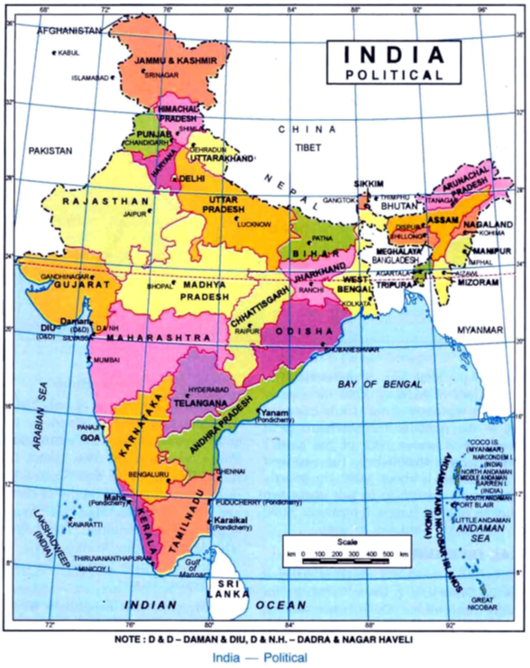
The Himalayas stretch from Kashmir in the west to Arunachal in the east covering a distance of 2,400 km in a gigantic arc. They vary in width from 240 to 320 km. The Himalayas can be divided into three zones –– The Himadri or the Greater Himalayas with the highest and oldest peaks, the Himachal or the Middle Himalayas where most hill stations are located and the Shiwalik or the outer Himalayas, which are the southernmost range.
The Himachal also called the Greater Himalayas has an average height of 6,000 m and comprises the zone of high snow-capped peaks-apt for its name Him-alaya meaning abode of snow. It has the loftiest peak of the world-Mount Everest with a height of 8,848 m, located in Nepal. Some of the other important peaks are Kanchenjunga in Sikkim (8,598 m), Dhaulagiri (8,177 m), Nanga Parbat (8,126 m) and Nanda Devi (7,818 m). The Gangotri and Jamnotri glaciers are found here and the Rivers Ganga and Yamuna originate from these glaciers.
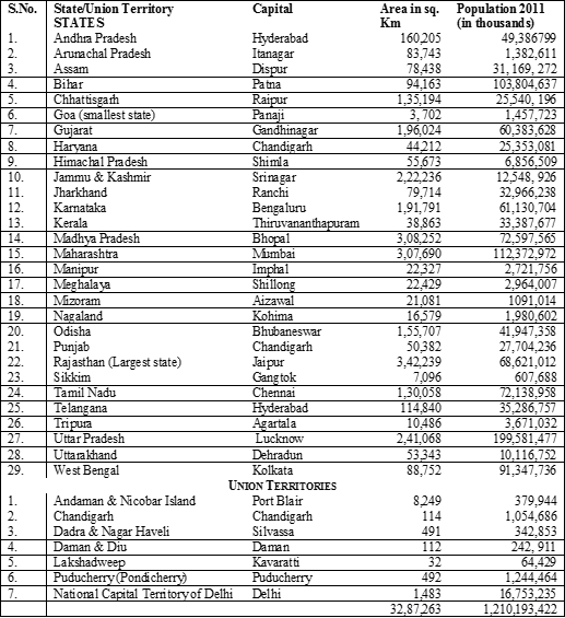
The Shiwalik also called the Outer Himalayas has an average height of 1,200 m. They extend along the foot of the Himachal from the Potwar plateau and the Bannu plains on the west to the Brahmaputra Valley on the east. There are broad valleys between the Himachal and Shiwalik ranges known as duns. Dehradun and Patli dun are two such duns. The northern parts of Punjab, Himachal Pradesh, Uttarakhand, UP, Bihar and a small portion of Bengal lie here. The eastern part of Shiwalik is known as Poorvanchal. It consists of the Khasi, Jaintla, Mizo and Naga hills, and the Patkai Bum, spanning across the states of Assam, Meghalaya, Nagaland, Mizoram, Manipur and the Union Territory of Arunachal Pradesh. Along the foothills of the Shiwaliks, the plains have a deposition of gravel, pebbles and sand brought down by the rivers. It is known as Bhabar. To the south of bhabar is the Terai plain, a belt of marshy grasslands where water flow down making it a marshy land. The Terai is an agriculturally productive and heavily forested area.