 Param Publication
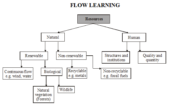
Types - natural and human;
- Books Name
- Private Course Testing Social Science Book
- Publication
- Param Publication
- Course
- CBSE Class 10
- Subject
- Social Science
INTRODUCTION :
“Resources are generally considered as gifts of nature”. Resources are actually a function of human activities. They transform material available in our environment into resources and use them.
Plants, animals, land, water and minerals are termed as natural resources.
By utilizing natural resources, humans created their own world of living. They created building, roads, railways, town, machines, industries etc.
Important Terms
Individual Resources : The resources owned privately by individuals.
National Resources : The resources that belong to the nation.
International Resources : The resources that do not belong to any individual country.
Resources Planning : The widely accepted strategy for cautious use of resources is known as resource planning.
Gross Cropped Area : Area sown more than once in an agricultural year plus net sown area is known as gross cropped area.
Soil Erosion : The removal of top fertile soil cover due to various reasons like wind, glacier and water is called soil erosion.
Gullies : The running water cuts through the clayey soils and makes deep channels known as gullies.
Bad Land or Ravines : Due to the formation of gullies the land becomes unfit for cultivation and is known as bad land or ravines.
Sheet Erosion : When the top soil is washed away due to heavy flow of water down the slopes it is known as sheet erosion.
Wind Erosion : When the top fertile soil blows off due to wind it is known as wind erosion.
Shelter Belts : Planting lines of trees to create shelter breaks up the force of the wind. Rows of such trees are called shelter belts.
concept of resources :
(i) Everything available in our environment which can be used to satisfy our needs, provided, it is technologically accessible, economically feasible and culturally acceptable can be termed as ‘Resource’.
(ii) The process of transformation of things available in our environment involves an inter-dependent relationship between nature, technology and institution.
(iii) Human beings interact with nature through technology and create institutions to accelerate their economic development.
Illustration 1 : What is a resource?
Solution : Everything available in environment which is technologically accessible, economically feasible and culturally acceptable.
Illustration 2 : How do human beings interact with to speed up their economic development?
Solution : Human beings interact with nature through technology.
Types - natural and human;
- Books Name
- Testing Private Course Social Science Book
- Publication
- Param Publication
- Course
- CBSE Class 10
- Subject
- Social Science
INTRODUCTION :
“Resources are generally considered as gifts of nature”. Resources are actually a function of human activities. They transform material available in our environment into resources and use them.
Plants, animals, land, water and minerals are termed as natural resources.
By utilizing natural resources, humans created their own world of living. They created building, roads, railways, town, machines, industries etc.
Important Terms
Individual Resources : The resources owned privately by individuals.
National Resources : The resources that belong to the nation.
International Resources : The resources that do not belong to any individual country.
Resources Planning : The widely accepted strategy for cautious use of resources is known as resource planning.
Gross Cropped Area : Area sown more than once in an agricultural year plus net sown area is known as gross cropped area.
Soil Erosion : The removal of top fertile soil cover due to various reasons like wind, glacier and water is called soil erosion.
Gullies : The running water cuts through the clayey soils and makes deep channels known as gullies.
Bad Land or Ravines : Due to the formation of gullies the land becomes unfit for cultivation and is known as bad land or ravines.
Sheet Erosion : When the top soil is washed away due to heavy flow of water down the slopes it is known as sheet erosion.
Wind Erosion : When the top fertile soil blows off due to wind it is known as wind erosion.
Shelter Belts : Planting lines of trees to create shelter breaks up the force of the wind. Rows of such trees are called shelter belts.
concept of resources :
(i) Everything available in our environment which can be used to satisfy our needs, provided, it is technologically accessible, economically feasible and culturally acceptable can be termed as ‘Resource’.
(ii) The process of transformation of things available in our environment involves an inter-dependent relationship between nature, technology and institution.
(iii) Human beings interact with nature through technology and create institutions to accelerate their economic development.
Illustration 1 : What is a resource?
Solution : Everything available in environment which is technologically accessible, economically feasible and culturally acceptable.
Illustration 2 : How do human beings interact with to speed up their economic development?
Solution : Human beings interact with nature through technology.
Types - natural and human;
- Books Name
- Testing Private Course English Book
- Publication
- Param Publication
- Course
- CBSE Class 10
- Subject
- Social Science
INTRODUCTION :
“Resources are generally considered as gifts of nature”. Resources are actually a function of human activities. They transform material available in our environment into resources and use them.
Plants, animals, land, water and minerals are termed as natural resources.
By utilizing natural resources, humans created their own world of living. They created building, roads, railways, town, machines, industries etc.
Important Terms
Individual Resources : The resources owned privately by individuals.
National Resources : The resources that belong to the nation.
International Resources : The resources that do not belong to any individual country.
Resources Planning : The widely accepted strategy for cautious use of resources is known as resource planning.
Gross Cropped Area : Area sown more than once in an agricultural year plus net sown area is known as gross cropped area.
Soil Erosion : The removal of top fertile soil cover due to various reasons like wind, glacier and water is called soil erosion.
Gullies : The running water cuts through the clayey soils and makes deep channels known as gullies.
Bad Land or Ravines : Due to the formation of gullies the land becomes unfit for cultivation and is known as bad land or ravines.
Sheet Erosion : When the top soil is washed away due to heavy flow of water down the slopes it is known as sheet erosion.
Wind Erosion : When the top fertile soil blows off due to wind it is known as wind erosion.
Shelter Belts : Planting lines of trees to create shelter breaks up the force of the wind. Rows of such trees are called shelter belts.
concept of resources :
(i) Everything available in our environment which can be used to satisfy our needs, provided, it is technologically accessible, economically feasible and culturally acceptable can be termed as ‘Resource’.
(ii) The process of transformation of things available in our environment involves an inter-dependent relationship between nature, technology and institution.
(iii) Human beings interact with nature through technology and create institutions to accelerate their economic development.
Illustration 1 : What is a resource?
Solution : Everything available in environment which is technologically accessible, economically feasible and culturally acceptable.
Illustration 2 : How do human beings interact with to speed up their economic development?
Solution : Human beings interact with nature through technology.
Types - natural and human;
- Books Name
- Testing Private Course Hindi Book
- Publication
- Param Publication
- Course
- CBSE Class 10
- Subject
- Social Science
INTRODUCTION :
“Resources are generally considered as gifts of nature”. Resources are actually a function of human activities. They transform material available in our environment into resources and use them.
Plants, animals, land, water and minerals are termed as natural resources.
By utilizing natural resources, humans created their own world of living. They created building, roads, railways, town, machines, industries etc.
Important Terms
Individual Resources : The resources owned privately by individuals.
National Resources : The resources that belong to the nation.
International Resources : The resources that do not belong to any individual country.
Resources Planning : The widely accepted strategy for cautious use of resources is known as resource planning.
Gross Cropped Area : Area sown more than once in an agricultural year plus net sown area is known as gross cropped area.
Soil Erosion : The removal of top fertile soil cover due to various reasons like wind, glacier and water is called soil erosion.
Gullies : The running water cuts through the clayey soils and makes deep channels known as gullies.
Bad Land or Ravines : Due to the formation of gullies the land becomes unfit for cultivation and is known as bad land or ravines.
Sheet Erosion : When the top soil is washed away due to heavy flow of water down the slopes it is known as sheet erosion.
Wind Erosion : When the top fertile soil blows off due to wind it is known as wind erosion.
Shelter Belts : Planting lines of trees to create shelter breaks up the force of the wind. Rows of such trees are called shelter belts.
concept of resources :
(i) Everything available in our environment which can be used to satisfy our needs, provided, it is technologically accessible, economically feasible and culturally acceptable can be termed as ‘Resource’.
(ii) The process of transformation of things available in our environment involves an inter-dependent relationship between nature, technology and institution.
(iii) Human beings interact with nature through technology and create institutions to accelerate their economic development.
Illustration 1 : What is a resource?
Solution : Everything available in environment which is technologically accessible, economically feasible and culturally acceptable.
Illustration 2 : How do human beings interact with to speed up their economic development?
Solution : Human beings interact with nature through technology.
Types - natural and human;
- Books Name
- Private Course Testing Modules English Book
- Publication
- Param Publication
- Course
- CBSE Class 10
- Subject
- Social Science
INTRODUCTION :
“Resources are generally considered as gifts of nature”. Resources are actually a function of human activities. They transform material available in our environment into resources and use them.
Plants, animals, land, water and minerals are termed as natural resources.
By utilizing natural resources, humans created their own world of living. They created building, roads, railways, town, machines, industries etc.
Important Terms
Individual Resources : The resources owned privately by individuals.
National Resources : The resources that belong to the nation.
International Resources : The resources that do not belong to any individual country.
Resources Planning : The widely accepted strategy for cautious use of resources is known as resource planning.
Gross Cropped Area : Area sown more than once in an agricultural year plus net sown area is known as gross cropped area.
Soil Erosion : The removal of top fertile soil cover due to various reasons like wind, glacier and water is called soil erosion.
Gullies : The running water cuts through the clayey soils and makes deep channels known as gullies.
Bad Land or Ravines : Due to the formation of gullies the land becomes unfit for cultivation and is known as bad land or ravines.
Sheet Erosion : When the top soil is washed away due to heavy flow of water down the slopes it is known as sheet erosion.
Wind Erosion : When the top fertile soil blows off due to wind it is known as wind erosion.
Shelter Belts : Planting lines of trees to create shelter breaks up the force of the wind. Rows of such trees are called shelter belts.
concept of resources :
(i) Everything available in our environment which can be used to satisfy our needs, provided, it is technologically accessible, economically feasible and culturally acceptable can be termed as ‘Resource’.
(ii) The process of transformation of things available in our environment involves an inter-dependent relationship between nature, technology and institution.
(iii) Human beings interact with nature through technology and create institutions to accelerate their economic development.
Illustration 1 : What is a resource?
Solution : Everything available in environment which is technologically accessible, economically feasible and culturally acceptable.
Illustration 2 : How do human beings interact with to speed up their economic development?
Solution : Human beings interact with nature through technology.
Types - natural and human;
- Books Name
- Private Course Testing Modules Hindi Book
- Publication
- Param Publication
- Course
- CBSE Class 10
- Subject
- Social Science
INTRODUCTION :
“Resources are generally considered as gifts of nature”. Resources are actually a function of human activities. They transform material available in our environment into resources and use them.
Plants, animals, land, water and minerals are termed as natural resources.
By utilizing natural resources, humans created their own world of living. They created building, roads, railways, town, machines, industries etc.
Important Terms
Individual Resources : The resources owned privately by individuals.
National Resources : The resources that belong to the nation.
International Resources : The resources that do not belong to any individual country.
Resources Planning : The widely accepted strategy for cautious use of resources is known as resource planning.
Gross Cropped Area : Area sown more than once in an agricultural year plus net sown area is known as gross cropped area.
Soil Erosion : The removal of top fertile soil cover due to various reasons like wind, glacier and water is called soil erosion.
Gullies : The running water cuts through the clayey soils and makes deep channels known as gullies.
Bad Land or Ravines : Due to the formation of gullies the land becomes unfit for cultivation and is known as bad land or ravines.
Sheet Erosion : When the top soil is washed away due to heavy flow of water down the slopes it is known as sheet erosion.
Wind Erosion : When the top fertile soil blows off due to wind it is known as wind erosion.
Shelter Belts : Planting lines of trees to create shelter breaks up the force of the wind. Rows of such trees are called shelter belts.
concept of resources :
(i) Everything available in our environment which can be used to satisfy our needs, provided, it is technologically accessible, economically feasible and culturally acceptable can be termed as ‘Resource’.
(ii) The process of transformation of things available in our environment involves an inter-dependent relationship between nature, technology and institution.
(iii) Human beings interact with nature through technology and create institutions to accelerate their economic development.
Illustration 1 : What is a resource?
Solution : Everything available in environment which is technologically accessible, economically feasible and culturally acceptable.
Illustration 2 : How do human beings interact with to speed up their economic development?
Solution : Human beings interact with nature through technology.
Need for resource planning, natural resources, land as a resource, soil types and distribution.
- Books Name
- Private Course Testing Social Science Book
- Publication
- Param Publication
- Course
- CBSE Class 10
- Subject
- Social Science
Resource planning and stages of resources planning :
Resource Planning :
Planning is the widely accepted strategy for judicious use of resources. It has importance in a country like India, which has enormous diversity in the availability of resources.
Stages of Resources Planning :
Resource planning is a complex process which involves
(i) Identification and inventory of resources across the regions of the country. This involves surveying, mapping and qualitative and quantitative estimation and measurement of the resources.
(ii) Evolving a planning structure endowed with appropriate technology, skill and institutional set up for implementing resource development plans.
(iii) Matching the resource development plans with overall national development plans.
Illustration 6 : What are Chhatisgarh & M.P. rich in?
Solution : Minerals & coal deposits
Illustration 7 : What does Rajasthan lacks in?
Solution : Water resources
Illustration 8 : What is Ladakh rich in?
Solution : Cultural heritage
conservation of resources and land resources :
Conservation Of Resources :
Resources are vital for any developmental activity. But irrational consumption and over-utilisation of resources may lead to socio-economic and environmental problems. To overcome these problems, resource conservation at various levels is important.
Example: Gandhiji was very apt in voicing his concern about resource conservation in these words: “There is enough for everybody’s need and not for any body’s greed.”
Land Resources :
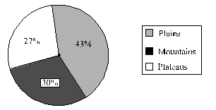
About 43 per cent of the land area is plain, which provides facilities for agriculture and industry.
Mountains account for 30 per cent of the total surface area of the country and ensure perennial flow of some rivers, provide facilities for tourism and ecological aspects.
About 27 per cent of the area of the country is the plateau region. It possesses rich reserves of minerals, fossil fuels and forests.
Illustration 9 : Who voiced his concern about conservation of resources?
Solution : Gandhiji
Illustration 10 : What is the percentage of plains in India?
Solution : 43%
Illustration 11 : What is the % of plateau region?
Solution : 27%
Need for resource planning, natural resources, land as a resource, soil types and distribution.
- Books Name
- Testing Private Course Social Science Book
- Publication
- Param Publication
- Course
- CBSE Class 10
- Subject
- Social Science
Resource planning and stages of resources planning :
Resource Planning :
Planning is the widely accepted strategy for judicious use of resources. It has importance in a country like India, which has enormous diversity in the availability of resources.
Stages of Resources Planning :
Resource planning is a complex process which involves
(i) Identification and inventory of resources across the regions of the country. This involves surveying, mapping and qualitative and quantitative estimation and measurement of the resources.
(ii) Evolving a planning structure endowed with appropriate technology, skill and institutional set up for implementing resource development plans.
(iii) Matching the resource development plans with overall national development plans.
Illustration 6 : What are Chhatisgarh & M.P. rich in?
Solution : Minerals & coal deposits
Illustration 7 : What does Rajasthan lacks in?
Solution : Water resources
Illustration 8 : What is Ladakh rich in?
Solution : Cultural heritage
conservation of resources and land resources :
Conservation Of Resources :
Resources are vital for any developmental activity. But irrational consumption and over-utilisation of resources may lead to socio-economic and environmental problems. To overcome these problems, resource conservation at various levels is important.
Example: Gandhiji was very apt in voicing his concern about resource conservation in these words: “There is enough for everybody’s need and not for any body’s greed.”
Land Resources :
About 43 per cent of the land area is plain, which provides facilities for agriculture and industry.
Mountains account for 30 per cent of the total surface area of the country and ensure perennial flow of some rivers, provide facilities for tourism and ecological aspects.
About 27 per cent of the area of the country is the plateau region. It possesses rich reserves of minerals, fossil fuels and forests.
Illustration 9 : Who voiced his concern about conservation of resources?
Solution : Gandhiji
Illustration 10 : What is the percentage of plains in India?
Solution : 43%
Illustration 11 : What is the % of plateau region?
Solution : 27%
Need for resource planning, natural resources, land as a resource, soil types and distribution.
- Books Name
- Testing Private Course English Book
- Publication
- Param Publication
- Course
- CBSE Class 10
- Subject
- Social Science
Resource planning and stages of resources planning :
Resource Planning :
Planning is the widely accepted strategy for judicious use of resources. It has importance in a country like India, which has enormous diversity in the availability of resources.
Stages of Resources Planning :
Resource planning is a complex process which involves
(i) Identification and inventory of resources across the regions of the country. This involves surveying, mapping and qualitative and quantitative estimation and measurement of the resources.
(ii) Evolving a planning structure endowed with appropriate technology, skill and institutional set up for implementing resource development plans.
(iii) Matching the resource development plans with overall national development plans.
Illustration 6 : What are Chhatisgarh & M.P. rich in?
Solution : Minerals & coal deposits
Illustration 7 : What does Rajasthan lacks in?
Solution : Water resources
Illustration 8 : What is Ladakh rich in?
Solution : Cultural heritage
conservation of resources and land resources :
Conservation Of Resources :
Resources are vital for any developmental activity. But irrational consumption and over-utilisation of resources may lead to socio-economic and environmental problems. To overcome these problems, resource conservation at various levels is important.
Example: Gandhiji was very apt in voicing his concern about resource conservation in these words: “There is enough for everybody’s need and not for any body’s greed.”
Land Resources :
About 43 per cent of the land area is plain, which provides facilities for agriculture and industry.
Mountains account for 30 per cent of the total surface area of the country and ensure perennial flow of some rivers, provide facilities for tourism and ecological aspects.
About 27 per cent of the area of the country is the plateau region. It possesses rich reserves of minerals, fossil fuels and forests.
Illustration 9 : Who voiced his concern about conservation of resources?
Solution : Gandhiji
Illustration 10 : What is the percentage of plains in India?
Solution : 43%
Illustration 11 : What is the % of plateau region?
Solution : 27%
Need for resource planning, natural resources, land as a resource, soil types and distribution.
- Books Name
- Testing Private Course Hindi Book
- Publication
- Param Publication
- Course
- CBSE Class 10
- Subject
- Social Science
Resource planning and stages of resources planning :
Resource Planning :
Planning is the widely accepted strategy for judicious use of resources. It has importance in a country like India, which has enormous diversity in the availability of resources.
Stages of Resources Planning :
Resource planning is a complex process which involves
(i) Identification and inventory of resources across the regions of the country. This involves surveying, mapping and qualitative and quantitative estimation and measurement of the resources.
(ii) Evolving a planning structure endowed with appropriate technology, skill and institutional set up for implementing resource development plans.
(iii) Matching the resource development plans with overall national development plans.
Illustration 6 : What are Chhatisgarh & M.P. rich in?
Solution : Minerals & coal deposits
Illustration 7 : What does Rajasthan lacks in?
Solution : Water resources
Illustration 8 : What is Ladakh rich in?
Solution : Cultural heritage
conservation of resources and land resources :
Conservation Of Resources :
Resources are vital for any developmental activity. But irrational consumption and over-utilisation of resources may lead to socio-economic and environmental problems. To overcome these problems, resource conservation at various levels is important.
Example: Gandhiji was very apt in voicing his concern about resource conservation in these words: “There is enough for everybody’s need and not for any body’s greed.”
Land Resources :
About 43 per cent of the land area is plain, which provides facilities for agriculture and industry.
Mountains account for 30 per cent of the total surface area of the country and ensure perennial flow of some rivers, provide facilities for tourism and ecological aspects.
About 27 per cent of the area of the country is the plateau region. It possesses rich reserves of minerals, fossil fuels and forests.
Illustration 9 : Who voiced his concern about conservation of resources?
Solution : Gandhiji
Illustration 10 : What is the percentage of plains in India?
Solution : 43%
Illustration 11 : What is the % of plateau region?
Solution : 27%
Need for resource planning, natural resources, land as a resource, soil types and distribution.
- Books Name
- Private Course Testing Modules English Book
- Publication
- Param Publication
- Course
- CBSE Class 10
- Subject
- Social Science
Resource planning and stages of resources planning :
Resource Planning :
Planning is the widely accepted strategy for judicious use of resources. It has importance in a country like India, which has enormous diversity in the availability of resources.
Stages of Resources Planning :
Resource planning is a complex process which involves
(i) Identification and inventory of resources across the regions of the country. This involves surveying, mapping and qualitative and quantitative estimation and measurement of the resources.
(ii) Evolving a planning structure endowed with appropriate technology, skill and institutional set up for implementing resource development plans.
(iii) Matching the resource development plans with overall national development plans.
Illustration 6 : What are Chhatisgarh & M.P. rich in?
Solution : Minerals & coal deposits
Illustration 7 : What does Rajasthan lacks in?
Solution : Water resources
Illustration 8 : What is Ladakh rich in?
Solution : Cultural heritage
conservation of resources and land resources :
Conservation Of Resources :
Resources are vital for any developmental activity. But irrational consumption and over-utilisation of resources may lead to socio-economic and environmental problems. To overcome these problems, resource conservation at various levels is important.
Example: Gandhiji was very apt in voicing his concern about resource conservation in these words: “There is enough for everybody’s need and not for any body’s greed.”
Land Resources :
About 43 per cent of the land area is plain, which provides facilities for agriculture and industry.
Mountains account for 30 per cent of the total surface area of the country and ensure perennial flow of some rivers, provide facilities for tourism and ecological aspects.
About 27 per cent of the area of the country is the plateau region. It possesses rich reserves of minerals, fossil fuels and forests.
Illustration 9 : Who voiced his concern about conservation of resources?
Solution : Gandhiji
Illustration 10 : What is the percentage of plains in India?
Solution : 43%
Illustration 11 : What is the % of plateau region?
Solution : 27%
Need for resource planning, natural resources, land as a resource, soil types and distribution.
- Books Name
- Private Course Testing Modules Hindi Book
- Publication
- Param Publication
- Course
- CBSE Class 10
- Subject
- Social Science
Resource planning and stages of resources planning :
Resource Planning :
Planning is the widely accepted strategy for judicious use of resources. It has importance in a country like India, which has enormous diversity in the availability of resources.
Stages of Resources Planning :
Resource planning is a complex process which involves
(i) Identification and inventory of resources across the regions of the country. This involves surveying, mapping and qualitative and quantitative estimation and measurement of the resources.
(ii) Evolving a planning structure endowed with appropriate technology, skill and institutional set up for implementing resource development plans.
(iii) Matching the resource development plans with overall national development plans.
Illustration 6 : What are Chhatisgarh & M.P. rich in?
Solution : Minerals & coal deposits
Illustration 7 : What does Rajasthan lacks in?
Solution : Water resources
Illustration 8 : What is Ladakh rich in?
Solution : Cultural heritage
conservation of resources and land resources :
Conservation Of Resources :
Resources are vital for any developmental activity. But irrational consumption and over-utilisation of resources may lead to socio-economic and environmental problems. To overcome these problems, resource conservation at various levels is important.
Example: Gandhiji was very apt in voicing his concern about resource conservation in these words: “There is enough for everybody’s need and not for any body’s greed.”
Land Resources :
About 43 per cent of the land area is plain, which provides facilities for agriculture and industry.
Mountains account for 30 per cent of the total surface area of the country and ensure perennial flow of some rivers, provide facilities for tourism and ecological aspects.
About 27 per cent of the area of the country is the plateau region. It possesses rich reserves of minerals, fossil fuels and forests.
Illustration 9 : Who voiced his concern about conservation of resources?
Solution : Gandhiji
Illustration 10 : What is the percentage of plains in India?
Solution : 43%
Illustration 11 : What is the % of plateau region?
Solution : 27%
Changing land-use pattern.
- Books Name
- Private Course Testing Social Science Book
- Publication
- Param Publication
- Course
- CBSE Class 10
- Subject
- Social Science
land use pattern in India :
Land Use Pattern In India :
The use of land is determined both by physical factors such as topography, climate, soil types as well as human factors such as population density, technological capability and culture and traditions etc.
Points
(i) The land under permanent pasture has decreased.
(ii) Most of the other than the current fallow lands are either of poor quality or the cost of cultivation of such land is very high.
(iii) Hence, these lands are cultivated once or twice in about two to three years and if these are included in the net sown area then the percentage of NSA in India comes to about 54 per cent of the total reporting area.
(iv) The pattern of net sown area varies greatly from one state to another. It is over 80 per cent of the total area in Punjab and Haryana and less than 10 per cent in Arunachal Pradesh, Mizoram, Manipur and Andaman Nicobar Islands.
(v) Forest area in the country is far lower than the desired 33 per cent of geographical area, as it was outlined in the National Forest Policy (1952). It was considered essential for maintenance of the ecological balance.
(vi) A part of the land is termed as waste land and land put to other non-agricultural uses.
(vii) Waste land includes rocky, arid and desert areas and land put to other non-agricultural uses includes settlements, roads, railways, industry etc.
(viii) Continuous use of land over a long period of time without taking appropriate measures to conserve and manage it, has resulted in land degradation.
(ix) It has serious repercussions on society and the environment.
Illustration 12 : Mention the physical factors which determine the use of land.
Solution : Climate, type of soils and topography
Illustration 13 : How much forest area was desired in the National forest policy?
Solution : 33%
Illustration 14 : What are the non-agricultural uses of land?
Solution : It includes roads, railways, industries, settlements etc.
Changing land-use pattern.
- Books Name
- Testing Private Course Social Science Book
- Publication
- Param Publication
- Course
- CBSE Class 10
- Subject
- Social Science
land use pattern in India :
Land Use Pattern In India :
The use of land is determined both by physical factors such as topography, climate, soil types as well as human factors such as population density, technological capability and culture and traditions etc.
Points
(i) The land under permanent pasture has decreased.
(ii) Most of the other than the current fallow lands are either of poor quality or the cost of cultivation of such land is very high.
(iii) Hence, these lands are cultivated once or twice in about two to three years and if these are included in the net sown area then the percentage of NSA in India comes to about 54 per cent of the total reporting area.
(iv) The pattern of net sown area varies greatly from one state to another. It is over 80 per cent of the total area in Punjab and Haryana and less than 10 per cent in Arunachal Pradesh, Mizoram, Manipur and Andaman Nicobar Islands.
(v) Forest area in the country is far lower than the desired 33 per cent of geographical area, as it was outlined in the National Forest Policy (1952). It was considered essential for maintenance of the ecological balance.
(vi) A part of the land is termed as waste land and land put to other non-agricultural uses.
(vii) Waste land includes rocky, arid and desert areas and land put to other non-agricultural uses includes settlements, roads, railways, industry etc.
(viii) Continuous use of land over a long period of time without taking appropriate measures to conserve and manage it, has resulted in land degradation.
(ix) It has serious repercussions on society and the environment.
Illustration 12 : Mention the physical factors which determine the use of land.
Solution : Climate, type of soils and topography
Illustration 13 : How much forest area was desired in the National forest policy?
Solution : 33%
Illustration 14 : What are the non-agricultural uses of land?
Solution : It includes roads, railways, industries, settlements etc.
Changing land-use pattern.
- Books Name
- Testing Private Course English Book
- Publication
- Param Publication
- Course
- CBSE Class 10
- Subject
- Social Science
land use pattern in India :
Land Use Pattern In India :
The use of land is determined both by physical factors such as topography, climate, soil types as well as human factors such as population density, technological capability and culture and traditions etc.
Points
(i) The land under permanent pasture has decreased.
(ii) Most of the other than the current fallow lands are either of poor quality or the cost of cultivation of such land is very high.
(iii) Hence, these lands are cultivated once or twice in about two to three years and if these are included in the net sown area then the percentage of NSA in India comes to about 54 per cent of the total reporting area.
(iv) The pattern of net sown area varies greatly from one state to another. It is over 80 per cent of the total area in Punjab and Haryana and less than 10 per cent in Arunachal Pradesh, Mizoram, Manipur and Andaman Nicobar Islands.
(v) Forest area in the country is far lower than the desired 33 per cent of geographical area, as it was outlined in the National Forest Policy (1952). It was considered essential for maintenance of the ecological balance.
(vi) A part of the land is termed as waste land and land put to other non-agricultural uses.
(vii) Waste land includes rocky, arid and desert areas and land put to other non-agricultural uses includes settlements, roads, railways, industry etc.
(viii) Continuous use of land over a long period of time without taking appropriate measures to conserve and manage it, has resulted in land degradation.
(ix) It has serious repercussions on society and the environment.
Illustration 12 : Mention the physical factors which determine the use of land.
Solution : Climate, type of soils and topography
Illustration 13 : How much forest area was desired in the National forest policy?
Solution : 33%
Illustration 14 : What are the non-agricultural uses of land?
Solution : It includes roads, railways, industries, settlements etc.
Changing land-use pattern.
- Books Name
- Testing Private Course Hindi Book
- Publication
- Param Publication
- Course
- CBSE Class 10
- Subject
- Social Science
land use pattern in India :
Land Use Pattern In India :
The use of land is determined both by physical factors such as topography, climate, soil types as well as human factors such as population density, technological capability and culture and traditions etc.
Points
(i) The land under permanent pasture has decreased.
(ii) Most of the other than the current fallow lands are either of poor quality or the cost of cultivation of such land is very high.
(iii) Hence, these lands are cultivated once or twice in about two to three years and if these are included in the net sown area then the percentage of NSA in India comes to about 54 per cent of the total reporting area.
(iv) The pattern of net sown area varies greatly from one state to another. It is over 80 per cent of the total area in Punjab and Haryana and less than 10 per cent in Arunachal Pradesh, Mizoram, Manipur and Andaman Nicobar Islands.
(v) Forest area in the country is far lower than the desired 33 per cent of geographical area, as it was outlined in the National Forest Policy (1952). It was considered essential for maintenance of the ecological balance.
(vi) A part of the land is termed as waste land and land put to other non-agricultural uses.
(vii) Waste land includes rocky, arid and desert areas and land put to other non-agricultural uses includes settlements, roads, railways, industry etc.
(viii) Continuous use of land over a long period of time without taking appropriate measures to conserve and manage it, has resulted in land degradation.
(ix) It has serious repercussions on society and the environment.
Illustration 12 : Mention the physical factors which determine the use of land.
Solution : Climate, type of soils and topography
Illustration 13 : How much forest area was desired in the National forest policy?
Solution : 33%
Illustration 14 : What are the non-agricultural uses of land?
Solution : It includes roads, railways, industries, settlements etc.
Changing land-use pattern.
- Books Name
- Private Course Testing Modules English Book
- Publication
- Param Publication
- Course
- CBSE Class 10
- Subject
- Social Science
land use pattern in India :
Land Use Pattern In India :
The use of land is determined both by physical factors such as topography, climate, soil types as well as human factors such as population density, technological capability and culture and traditions etc.
Points
(i) The land under permanent pasture has decreased.
(ii) Most of the other than the current fallow lands are either of poor quality or the cost of cultivation of such land is very high.
(iii) Hence, these lands are cultivated once or twice in about two to three years and if these are included in the net sown area then the percentage of NSA in India comes to about 54 per cent of the total reporting area.
(iv) The pattern of net sown area varies greatly from one state to another. It is over 80 per cent of the total area in Punjab and Haryana and less than 10 per cent in Arunachal Pradesh, Mizoram, Manipur and Andaman Nicobar Islands.
(v) Forest area in the country is far lower than the desired 33 per cent of geographical area, as it was outlined in the National Forest Policy (1952). It was considered essential for maintenance of the ecological balance.
(vi) A part of the land is termed as waste land and land put to other non-agricultural uses.
(vii) Waste land includes rocky, arid and desert areas and land put to other non-agricultural uses includes settlements, roads, railways, industry etc.
(viii) Continuous use of land over a long period of time without taking appropriate measures to conserve and manage it, has resulted in land degradation.
(ix) It has serious repercussions on society and the environment.
Illustration 12 : Mention the physical factors which determine the use of land.
Solution : Climate, type of soils and topography
Illustration 13 : How much forest area was desired in the National forest policy?
Solution : 33%
Illustration 14 : What are the non-agricultural uses of land?
Solution : It includes roads, railways, industries, settlements etc.
Changing land-use pattern.
- Books Name
- Private Course Testing Modules Hindi Book
- Publication
- Param Publication
- Course
- CBSE Class 10
- Subject
- Social Science
land use pattern in India :
Land Use Pattern In India :
The use of land is determined both by physical factors such as topography, climate, soil types as well as human factors such as population density, technological capability and culture and traditions etc.
Points
(i) The land under permanent pasture has decreased.
(ii) Most of the other than the current fallow lands are either of poor quality or the cost of cultivation of such land is very high.
(iii) Hence, these lands are cultivated once or twice in about two to three years and if these are included in the net sown area then the percentage of NSA in India comes to about 54 per cent of the total reporting area.
(iv) The pattern of net sown area varies greatly from one state to another. It is over 80 per cent of the total area in Punjab and Haryana and less than 10 per cent in Arunachal Pradesh, Mizoram, Manipur and Andaman Nicobar Islands.
(v) Forest area in the country is far lower than the desired 33 per cent of geographical area, as it was outlined in the National Forest Policy (1952). It was considered essential for maintenance of the ecological balance.
(vi) A part of the land is termed as waste land and land put to other non-agricultural uses.
(vii) Waste land includes rocky, arid and desert areas and land put to other non-agricultural uses includes settlements, roads, railways, industry etc.
(viii) Continuous use of land over a long period of time without taking appropriate measures to conserve and manage it, has resulted in land degradation.
(ix) It has serious repercussions on society and the environment.
Illustration 12 : Mention the physical factors which determine the use of land.
Solution : Climate, type of soils and topography
Illustration 13 : How much forest area was desired in the National forest policy?
Solution : 33%
Illustration 14 : What are the non-agricultural uses of land?
Solution : It includes roads, railways, industries, settlements etc.
Land degradation and conservation measures.
- Books Name
- Private Course Testing Social Science Book
- Publication
- Param Publication
- Course
- CBSE Class 10
- Subject
- Social Science
Land degradation and conservation measures :
Land Degradation :
Ninety-five per cent of our basic needs for food, shelter and clothing are obtained from land.
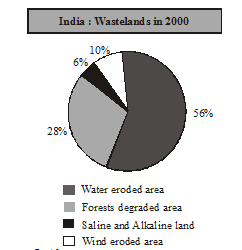
At present, there are about 130 million hectares of degraded land in India. Approximately, 28 per cent of it belongs to the category of forest degraded area, 56 per cent of it is water eroded area and the rest is affected by saline and alkaline deposites.
Wastelands :
.
Causes of Land Degradation :
(i) Some human activities such as deforestation, over grazing, mining and quarrying have contributed significantly in land degradation.
(ii) Mining sites are abandoned after excavation work is complete leaving deep scars and traces of over-burdening. In states like Jharkhand, Chhattisgarh, Madhya Pradesh and Orissa deforestation due to mining have caused severe land degradation.
(iii) In states like Gujarat, Rajasthan, Madhya Pradesh and Maharashtra overgrazing is one of the main reasons for land degradation.
(iv) In the states of Punjab, Haryana, western Uttar Pradesh, over irrigation is responsible for land degradation due to water logging leading to increase in salinity and alkalinity in the soil.
(v) The mineral processing like grinding of limestone for cement industry and calcite and soapstone for ceramic industry generate huge quantity of dust in the atmosphere. It retards the process of infiltration of water into the soil after it settles down on the land.
(vi) In recent years, industrial effluents as waste have become a major source of land and water pollution in many parts of the country.
Conservation measures :
(i) Afforestation and proper management of grazing can help to some extent.
(ii) Planting of shelter belts of plants, control on over grazing, stabilisation of sand dunes by growing thorny bushes.
(iii) Proper management of waste lands, control of mining activities, proper discharge and disposal of industrial effluents and wastes after treatment can reduce land and water degradation in industrial and suburban areas.
Illustration 15 : Name two states which suffer from deforestation due to minning.
Solution : Jharkhand and Orissa
Illustration 16 : Name two states where overgrazing is the major cause of land degradation.
Solution : Gujarat & Rajasthan
Illustration 17 : What is the major cause of land degradation is Punjab?
Solution : Over irrigation
Land degradation and conservation measures.
- Books Name
- Testing Private Course Social Science Book
- Publication
- Param Publication
- Course
- CBSE Class 10
- Subject
- Social Science
Land degradation and conservation measures :
Land Degradation :
Ninety-five per cent of our basic needs for food, shelter and clothing are obtained from land.
At present, there are about 130 million hectares of degraded land in India. Approximately, 28 per cent of it belongs to the category of forest degraded area, 56 per cent of it is water eroded area and the rest is affected by saline and alkaline deposites.
Wastelands :
.
Causes of Land Degradation :
(i) Some human activities such as deforestation, over grazing, mining and quarrying have contributed significantly in land degradation.
(ii) Mining sites are abandoned after excavation work is complete leaving deep scars and traces of over-burdening. In states like Jharkhand, Chhattisgarh, Madhya Pradesh and Orissa deforestation due to mining have caused severe land degradation.
(iii) In states like Gujarat, Rajasthan, Madhya Pradesh and Maharashtra overgrazing is one of the main reasons for land degradation.
(iv) In the states of Punjab, Haryana, western Uttar Pradesh, over irrigation is responsible for land degradation due to water logging leading to increase in salinity and alkalinity in the soil.
(v) The mineral processing like grinding of limestone for cement industry and calcite and soapstone for ceramic industry generate huge quantity of dust in the atmosphere. It retards the process of infiltration of water into the soil after it settles down on the land.
(vi) In recent years, industrial effluents as waste have become a major source of land and water pollution in many parts of the country.
Conservation measures :
(i) Afforestation and proper management of grazing can help to some extent.
(ii) Planting of shelter belts of plants, control on over grazing, stabilisation of sand dunes by growing thorny bushes.
(iii) Proper management of waste lands, control of mining activities, proper discharge and disposal of industrial effluents and wastes after treatment can reduce land and water degradation in industrial and suburban areas.
Illustration 15 : Name two states which suffer from deforestation due to minning.
Solution : Jharkhand and Orissa
Illustration 16 : Name two states where overgrazing is the major cause of land degradation.
Solution : Gujarat & Rajasthan
Illustration 17 : What is the major cause of land degradation is Punjab?
Solution : Over irrigation
Land degradation and conservation measures.
- Books Name
- Testing Private Course English Book
- Publication
- Param Publication
- Course
- CBSE Class 10
- Subject
- Social Science
Land degradation and conservation measures :
Land Degradation :
Ninety-five per cent of our basic needs for food, shelter and clothing are obtained from land.
At present, there are about 130 million hectares of degraded land in India. Approximately, 28 per cent of it belongs to the category of forest degraded area, 56 per cent of it is water eroded area and the rest is affected by saline and alkaline deposites.
Wastelands :
.
Causes of Land Degradation :
(i) Some human activities such as deforestation, over grazing, mining and quarrying have contributed significantly in land degradation.
(ii) Mining sites are abandoned after excavation work is complete leaving deep scars and traces of over-burdening. In states like Jharkhand, Chhattisgarh, Madhya Pradesh and Orissa deforestation due to mining have caused severe land degradation.
(iii) In states like Gujarat, Rajasthan, Madhya Pradesh and Maharashtra overgrazing is one of the main reasons for land degradation.
(iv) In the states of Punjab, Haryana, western Uttar Pradesh, over irrigation is responsible for land degradation due to water logging leading to increase in salinity and alkalinity in the soil.
(v) The mineral processing like grinding of limestone for cement industry and calcite and soapstone for ceramic industry generate huge quantity of dust in the atmosphere. It retards the process of infiltration of water into the soil after it settles down on the land.
(vi) In recent years, industrial effluents as waste have become a major source of land and water pollution in many parts of the country.
Conservation measures :
(i) Afforestation and proper management of grazing can help to some extent.
(ii) Planting of shelter belts of plants, control on over grazing, stabilisation of sand dunes by growing thorny bushes.
(iii) Proper management of waste lands, control of mining activities, proper discharge and disposal of industrial effluents and wastes after treatment can reduce land and water degradation in industrial and suburban areas.
Illustration 15 : Name two states which suffer from deforestation due to minning.
Solution : Jharkhand and Orissa
Illustration 16 : Name two states where overgrazing is the major cause of land degradation.
Solution : Gujarat & Rajasthan
Illustration 17 : What is the major cause of land degradation is Punjab?
Solution : Over irrigation
Land degradation and conservation measures.
- Books Name
- Testing Private Course Hindi Book
- Publication
- Param Publication
- Course
- CBSE Class 10
- Subject
- Social Science
Land degradation and conservation measures :
Land Degradation :
Ninety-five per cent of our basic needs for food, shelter and clothing are obtained from land.
At present, there are about 130 million hectares of degraded land in India. Approximately, 28 per cent of it belongs to the category of forest degraded area, 56 per cent of it is water eroded area and the rest is affected by saline and alkaline deposites.
Wastelands :
.
Causes of Land Degradation :
(i) Some human activities such as deforestation, over grazing, mining and quarrying have contributed significantly in land degradation.
(ii) Mining sites are abandoned after excavation work is complete leaving deep scars and traces of over-burdening. In states like Jharkhand, Chhattisgarh, Madhya Pradesh and Orissa deforestation due to mining have caused severe land degradation.
(iii) In states like Gujarat, Rajasthan, Madhya Pradesh and Maharashtra overgrazing is one of the main reasons for land degradation.
(iv) In the states of Punjab, Haryana, western Uttar Pradesh, over irrigation is responsible for land degradation due to water logging leading to increase in salinity and alkalinity in the soil.
(v) The mineral processing like grinding of limestone for cement industry and calcite and soapstone for ceramic industry generate huge quantity of dust in the atmosphere. It retards the process of infiltration of water into the soil after it settles down on the land.
(vi) In recent years, industrial effluents as waste have become a major source of land and water pollution in many parts of the country.
Conservation measures :
(i) Afforestation and proper management of grazing can help to some extent.
(ii) Planting of shelter belts of plants, control on over grazing, stabilisation of sand dunes by growing thorny bushes.
(iii) Proper management of waste lands, control of mining activities, proper discharge and disposal of industrial effluents and wastes after treatment can reduce land and water degradation in industrial and suburban areas.
Illustration 15 : Name two states which suffer from deforestation due to minning.
Solution : Jharkhand and Orissa
Illustration 16 : Name two states where overgrazing is the major cause of land degradation.
Solution : Gujarat & Rajasthan
Illustration 17 : What is the major cause of land degradation is Punjab?
Solution : Over irrigation
Land degradation and conservation measures.
- Books Name
- Private Course Testing Modules English Book
- Publication
- Param Publication
- Course
- CBSE Class 10
- Subject
- Social Science
Land degradation and conservation measures :
Land Degradation :
Ninety-five per cent of our basic needs for food, shelter and clothing are obtained from land.
At present, there are about 130 million hectares of degraded land in India. Approximately, 28 per cent of it belongs to the category of forest degraded area, 56 per cent of it is water eroded area and the rest is affected by saline and alkaline deposites.
Wastelands :
.
Causes of Land Degradation :
(i) Some human activities such as deforestation, over grazing, mining and quarrying have contributed significantly in land degradation.
(ii) Mining sites are abandoned after excavation work is complete leaving deep scars and traces of over-burdening. In states like Jharkhand, Chhattisgarh, Madhya Pradesh and Orissa deforestation due to mining have caused severe land degradation.
(iii) In states like Gujarat, Rajasthan, Madhya Pradesh and Maharashtra overgrazing is one of the main reasons for land degradation.
(iv) In the states of Punjab, Haryana, western Uttar Pradesh, over irrigation is responsible for land degradation due to water logging leading to increase in salinity and alkalinity in the soil.
(v) The mineral processing like grinding of limestone for cement industry and calcite and soapstone for ceramic industry generate huge quantity of dust in the atmosphere. It retards the process of infiltration of water into the soil after it settles down on the land.
(vi) In recent years, industrial effluents as waste have become a major source of land and water pollution in many parts of the country.
Conservation measures :
(i) Afforestation and proper management of grazing can help to some extent.
(ii) Planting of shelter belts of plants, control on over grazing, stabilisation of sand dunes by growing thorny bushes.
(iii) Proper management of waste lands, control of mining activities, proper discharge and disposal of industrial effluents and wastes after treatment can reduce land and water degradation in industrial and suburban areas.
Illustration 15 : Name two states which suffer from deforestation due to minning.
Solution : Jharkhand and Orissa
Illustration 16 : Name two states where overgrazing is the major cause of land degradation.
Solution : Gujarat & Rajasthan
Illustration 17 : What is the major cause of land degradation is Punjab?
Solution : Over irrigation
Land degradation and conservation measures.
- Books Name
- Private Course Testing Modules Hindi Book
- Publication
- Param Publication
- Course
- CBSE Class 10
- Subject
- Social Science
Land degradation and conservation measures :
Land Degradation :
Ninety-five per cent of our basic needs for food, shelter and clothing are obtained from land.
At present, there are about 130 million hectares of degraded land in India. Approximately, 28 per cent of it belongs to the category of forest degraded area, 56 per cent of it is water eroded area and the rest is affected by saline and alkaline deposites.
Wastelands :
.
Causes of Land Degradation :
(i) Some human activities such as deforestation, over grazing, mining and quarrying have contributed significantly in land degradation.
(ii) Mining sites are abandoned after excavation work is complete leaving deep scars and traces of over-burdening. In states like Jharkhand, Chhattisgarh, Madhya Pradesh and Orissa deforestation due to mining have caused severe land degradation.
(iii) In states like Gujarat, Rajasthan, Madhya Pradesh and Maharashtra overgrazing is one of the main reasons for land degradation.
(iv) In the states of Punjab, Haryana, western Uttar Pradesh, over irrigation is responsible for land degradation due to water logging leading to increase in salinity and alkalinity in the soil.
(v) The mineral processing like grinding of limestone for cement industry and calcite and soapstone for ceramic industry generate huge quantity of dust in the atmosphere. It retards the process of infiltration of water into the soil after it settles down on the land.
(vi) In recent years, industrial effluents as waste have become a major source of land and water pollution in many parts of the country.
Conservation measures :
(i) Afforestation and proper management of grazing can help to some extent.
(ii) Planting of shelter belts of plants, control on over grazing, stabilisation of sand dunes by growing thorny bushes.
(iii) Proper management of waste lands, control of mining activities, proper discharge and disposal of industrial effluents and wastes after treatment can reduce land and water degradation in industrial and suburban areas.
Illustration 15 : Name two states which suffer from deforestation due to minning.
Solution : Jharkhand and Orissa
Illustration 16 : Name two states where overgrazing is the major cause of land degradation.
Solution : Gujarat & Rajasthan
Illustration 17 : What is the major cause of land degradation is Punjab?
Solution : Over irrigation